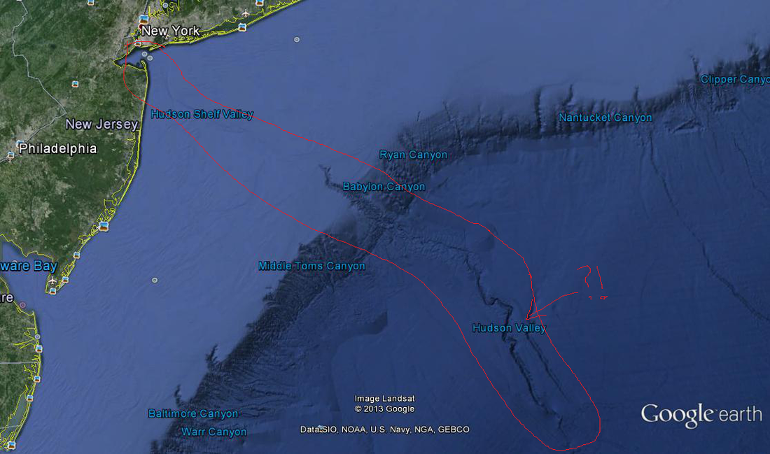
What's the jagged line coming from New York City past the continental shelf? Why does it say Hudson Valley?!
I want everyone to look at the above image from Google Earth. Years ago when I first used Google Earth I noticed this line cut into the seabed, but it originated in New York City. Then I began the research and visits to geology professors at my University to find out what exactly I was seeing. The answer is that this is the Hudson Shelf Valley, the Hudson Canyon, and the extension of the Hudson Valley. It's comparable to that of the Grand Canyon in the western United States. It is a submarine canyon that begins near the mouth of the present-day Hudson River and extends over FOUR HUNDRED (400) miles into the Atlantic!
Why don't people know about this? Because it's been underwater for a long time. In fact, it's been underwater for over 10,000 years.
During the Pleistocene Era the sea level was around 400 feet lower than it is today. The reduced sea level meant that the Hudson River flowed about 100 miles farther to the southeast of where it ends today. The river discharged sediments and cut out the canyon, much like it does today in the Hudson Valley. From there, the Hudson carved out a canyon underwater that extends 450 miles to the edge of the continental shelf of North America. Where the canyon meets the continental shelf, there is an abrupt 2-3+ mile drop in elevation.
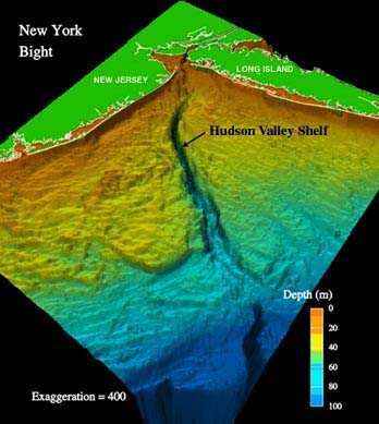
Underwater topography. Image courtesy of Hudson Canyon 2002, NOAA/OER.
The walls of the canyon range from 15-30 yards tall to about 3/4 of a mile tall at the continental shelf.
So can you just get in a submarine and travel down the "Hudson River" in the Atlantic? Not really. Years ago New York City used to throw all garbage into the Hudson; as a result, the garbage piled into the canyon.
Of course, why does any of this matter? Well first, it's really cool. Second, submarine canyons are potentially very dangerous. Because of the temperatures and pressures maintained in their depths, submarine canyons are known to contain pockets of methane hydrates. In fact there might be enough methane in the Hudson Canyon to power the United States for centuries. However, methane hydrates are unpredictable and if the gas is able to escape, it can cause massive turbulence on the ocean floor sometimes leading or triggering large earthquakes. In 1929 an earthquake measuring 7.2M occurred on the edge of the Grand Banks to the east of Nova Scotia. This earthquake was believed by some scientists to be caused by an underwater rock slide possibly caused by methane deposits shifting. A tsunami formed. This tsunami was anywhere between 10-25 feet tall though in narrow bays the wave was nearly 90 feet tall. Around 28 people died and the earthquake severely damaged underwater communication lines.
This could happen in the Hudson Canyon even without methane. An underwater rock slide causing a massive shift in a column of water could lead to a large tsunami/earthquake on the east coast. In addition, the Hudson Canyon is a path for most trans-Atlantic cables from and to the United States. Communications, including Internet, would be severely hindered by an underwater disaster in this area.
For now, it's pretty cool to look at and think about.
Thanks for reading.
Sources:
http://fopnews.wordpress.com/2010/01/29/off-new-york-citys-deep-end-a-pleistocene-grand-canyon/
http://oceanexplorer.noaa.gov/explorations/02hudson/welcome.html
http://www.whoi.edu/main/news-releases/1995-2004?tid=3622&cid=2078
 RSS Feed
