FIND MY PAGE ON FACEBOOK!!!!!!
The Weather Dork
  • Home
  • Educational Blogs

Worldwide Weather

1/8/2013

 
In most cases weather on the Earth evens itself out in the end...or at least it tries.  That is one of the reasons we get hurricanes in the Summer- the Earth is trying to "cool off" the equatorial latitudes and send warm air and moisture away toward the poles.  

Many people are talking about this warm up we're having.  Someone might see a 60 degree reading in the Hudson Valley before the end of the week.  This means no more snow pack.  In fact, I think it'll be gone by the weekend in most of the Hudson Valley.  

What it does not mean is that we won't see cold temperatures ever again.
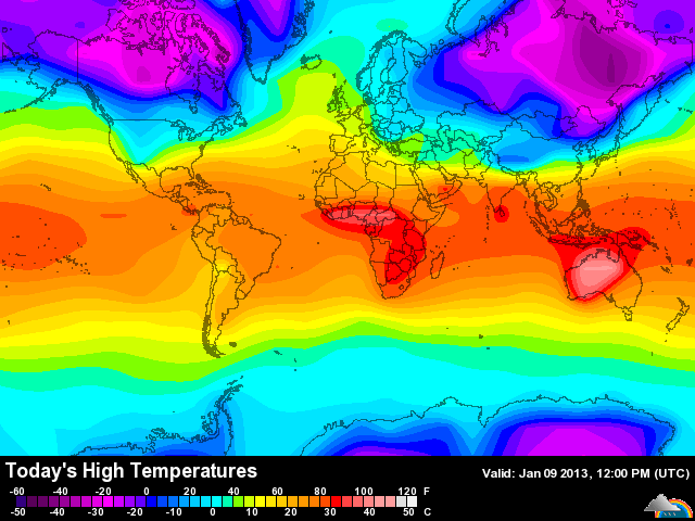
Picture
This map depicts the high temperatures today on the Earth.  Australia is dealing with dangerous and deadly temperatures pushing 120 degrees!  This heat is unheard of in much of the continent.  Wildfires are raging and firefighters and citizens are losing their lives or getting hurt.  

When you see extreme heat somewhere on the Earth you need to look for the opposite that balances out the climate in the atmosphere of the globe.  That opposite is in Siberia and northern Canada where HIGH temperatures are only reaching a dangerous -50 or so.  

The point of this short blog is that there are patterns at work on a global scale that are hardly ever mentioned but are always in place.  Think of the weather of the Earth as being gears in a clock- they all turn to keep the system going and each gear can change the entire system if it fails.  We will see cold air again in the United States- in fact, the cold air in Siberia may shift and spin into Canada with part of it kissing the northeast United States come the end of January.  This would mean low temperatures WELL below zero and highs, once again, in the single digits or so.

This pattern would also lend itself to wintery precipitation, especially in the Mid-Atlantic if the cold air really pushes south.  That is something to watch as we head into the second half of January.  

So if you like Winter and snow keep the faith.  If you don't like Winter and snow then enjoy the next few days.

Finally, trust that the Earth's atmosphere will do its best to balance temperatures and precipitation as well it can.  The weather may be deadly and dangerous but it is how our atmosphere maintains equilibrium.  If it can't maintain it, someone will get a giant storm to help balance things out.
Olbers' Paradox

12/7/2012

 
In 2005, when I was a senior in high school and didn't know much about science, I was staring at the night sky and came to a realization:

If the Universe is infinite, then why isn't the whole night sky full of stars?  

Think about it:  If the Universe is infinite there there are infinite stars in infinite angles in relation to Earth.  Therefore, the entire night sky should appear at least as bright as our own Star during the day.  Don't understand what I mean?  Look at this image, which represents what I'm talking about:


Picture
What the night sky SHOULD look like. Image via wikimedia.
I asked my 12th grade astronomy teacher if was I was thinking was right.  She said that theoretically yes, but distance plays a role in brightness.  I accepted that answer and moved on, until recently, when I thought about it again.  

There is a proper name for this phenomena, it's called Olbers' Paradox.   It is named after the German astronomer Heinrich Wilhelm Olbers and also called the "dark night sky paradox."  It is the argument that the darkness of the night sky conflicts with the assumption of an infinite and eternal static universe.  A static universe is a universe not expanding or contracting, but remaining the same.  

So why isn't the night sky as bright as our Sun?  Two theories when combined make sense.  

  • The Universe is expanding, so light from distant stars is pushed out of the visible spectrum as the wavelength increases.
  • The Universe is young and light from distant stars hasn't reached us yet.

The first reason essentially means that the Universe is not static, it's expanding (which is what I believe) and that light emitted from distant stars is slowly increased in wavelength down the visible spectrum to red and then out of the visible spectrum, making the light invisible to our eyes.  It doesn't mean we can't pick up the energy through other means (infrared, radio, etc.) but we just can't see it with our eyes.  So, in that sense, my teacher in 12th grade was very correct.

The second reason means that the Universe is not infinite, it's finite- it has an age, a size, and a finite amount of stars.  However, even if there are so many stars in the Universe we still could not escape seeing ALL of their light, therefore making the night sky much brighter than it is.   So what's the catch?  

Estimates are that the Universe is somewhere around 13.7 billion years old.  The catch is that light from stars that are more than 13.7 billion light years away (due to expansion) hasn't reached us yet and when it does the night sky will get brighter.  

Honestly the whole concept is confusing but I hope I was able to explain it a little bit.  The most important thing you should take away from this is that when someone says the Universe is infinite, you can ask them why, then, is the night sky not as bright as our own star.  Something to think about!

Thanks for reading, and trying to understand. 

The Devil's Catskills

11/26/2012

 
“Those were the days when the Devil was romping around in the Catskills.” – Frank Russell, Catskill resident.  

I will explain that quote in a moment but please note that this post is going to involve historical discussion of the Devil due to its place in Catskill lore.
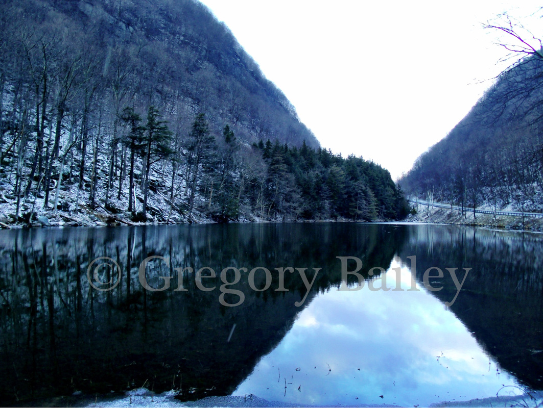
Picture
Direct your attention to image above. This is a photo that I took on Sunday in the Catskill Mountains.  The pond you see in the image is Notch Pond.  It is part of Stony Clove Creek and lies within the boundaries of Hunter, NY.  The “notch” name for the pond comes from the formation created by glacial melt water eroding its way through the gap between the mountains. 

The pond is part of the Devil’s Tombstone Campground.  The campground is one of the oldest in the state park system and it appears that it has been abandoned due to financial issues.  Still, route 214 passes through the campground, which lies in the valley between West Kill Mountain, Hunter Mountain, and Plateau Mountain.  You can access the location on Route 214. 

The “valley” that Route 214 and Notch Pond sit in is called Stony Clove Notch.  It was not as wide or as convenient as it is today.  It was overwhelmingly important but also was one of the most feared locations in the Catskill Mountains. 

Why was it so feared and how does the Devil come into the story of Stony Clove Notch?  The word “clove” comes from the Old Dutch “kloove.”  It means a gash or cut in the body of the Earth.  A settler or native that found the need to travel through a clove felt as though they were entering hell itself.  Layer upon layer of rock formed massive walls with sharp edges and cracks on both sides of the clove; safely venturing into the notch formed between the mountain took courage and luck because at any time a rock or tree could fall from the mountainside above and crush the traveler.  Indeed many people that entered Stony Clove Notch felt as though the walls of the mountains were closing in on them because they could only see a small patch of sky overhead between the cliffs. 

The pass was only a few feet wide and could barely fit a person.  If a thunderstorm came up while in the notch the traveler would be subjected to thunder that shook the mountains, water that poured on from the cliffs overhead, flash flooding in the pass, and rocks breaking off the mountainsides and falling. It is no wonder the entrance to Stony Clove Notch was believed to be the gates of hell. 

Charles Lanman, a painter and writer, said in the early 1840’s that Stony Clove “is the loneliest and most awful corner of the world that I have ever seen—none other, I fancy, could make a man feel more utterly desolate.  It is a type of the valley of the shadow of death; in single file did we have to pass through it and in single file must we pass to the grave…”  (Evers, 232). 

It was not just appearance that scared adventurers; it was the stories.  I have done much research on the folklore of the Catskill Mountains and have even lived where the Devil’s name identifies with many landmarks.  As a child I did not think much of these names but once I found the sources necessary to understand the origins I realized that the history of the Catskills and the Devil go far back. 

Alf Evers, in one of my favorite books, “The Catskills: From Wilderness to Woodstock” (1972), has an entire chapter on the workings of the Devil in the Catskill Mountains.  Here is an excerpt: 

“Devil lore is still very much in circulation among the Catskills.  And if the tales that are told are to be relied upon there can be no doubt that the Devil was once very active in the mountains.  He left the prints of his feet upon the rocks.  He strolled, he flew, he ran about the Catskills—he seems to have had a fondness for the region.  He was above all the good friend and adviser of the mountain witches, ever alert in prompting them to fresh acts of mischief and malevolence” (229). 

Evers cites the stories he heard from residents of the Devil appearing before farmers offering to clear their fields of rocks for one year in return for their immortal souls.  Another story mentions men playing cards on Saturday night deep in the Catskills.  They heard a noise outside and smelled a curious odor.  When they opened the door the Devil appeared to take them to Hell due to their Sabbath-breaking but they stopped playing cards just in time (230). 

I used to live near a place named Devil’s Kitchen where it was thought that the Devil did his cooking.  Giant boulders and various cliffs were the kitchenware and cooking surfaces of the Devil.  In the late 1800’s during the tourist boom in the Catskills the location was a hotspot for visitors.  The guides would tell visitors the stories of boulders being thrown around by the Devil.  Indeed when I was growing up I was told that the thunderous roar emanating from the mountain was the Devil banging his pots and pans in an attempt to cook during the weather.   

More specific to Stony Clove Notch, which is partially seen in the image, is the story (recounted by Evers) of a woodsman by the name of MacDaniel.  After finishing a hard day’s work in the upper valley north of the Notch, MacDaniel was trying to head home with his oxen.  While in the pass MacDaniel found that his oxen would not move one step more down the trail.  A fog settled into the notch and a figured appeared from the haze.  It was the Devil.  MacDaniel first swore at the figure in hopes it would flee but that only angered the spectre.   In desperation, MacDaniel fell to his knees and prayed.  The fog drifted away and the Devil disappeared.  MacDaniel was able to continue home. 

It is believed that after the visit to MacDaniel that the Devil died.  In fact, two objects closely associated with the Devil can be found not far from where I took this photograph.  One is in the campground and it is the Devil's Tombstone. The tombstone is a large boulder, approximately seven feet by five, which was probably carried down the mountain many centuries ago by a landslide or glacier.  There are no inscriptions on the stone but Alf Evers says that when the light hits the stone just right one can see ancient scratches and eroded pits on its surface. These scratches seem to arrange themselves into symbols of a forgotten language telling the tale of the Devil’s death (234).  Here is a postcard photo of the tombstone from 1908:  http://alturl.com/rjz3e and here is what it looks like today:  http://alturl.com/eucb9


The other object is on a nearby mountain.  It is the Devil’s Pulpit.  The Pulpit is a rock outcrop jutting out from the mountain where the Devil was said to hold his meetings with Catskill witches.   It can be seen here:  http://alturl.com/zb6qh

Stony Clove Notch, like all things that stand in the way of modernization, was tamed by machines.  In the late 1800’s the notch was widened enough to allow for a wagon and narrow rail line to pass through the gap.  Later the rail was upgraded to a standard width and used until 1940.  The rail bed is still visible in the eastern woods. In 1873 the Stoney Clove Turnpike Company upgraded the wagon road to allow for safer passage.  That wagon road would eventually become today’s Route 214.

Tales of the Devil were once common talk in the Catskill Mountains.  Today the Catskills have lost their ability to shock and mystify many people.  GPS, 4 wheel drive, and cell phones remove the fear of getting lost or stranded in the mountains.  The notches that required people to walk single file have been widened to allow passage of train and truck.  However, like I experienced over the weekend, if you pause and listen to the silence the Catskills have to offer you will feel a subliminal and surreal emotion that brings about thoughts of mystery and awe. 

The Ghost Ship of the Hudson River

10/31/2012

 
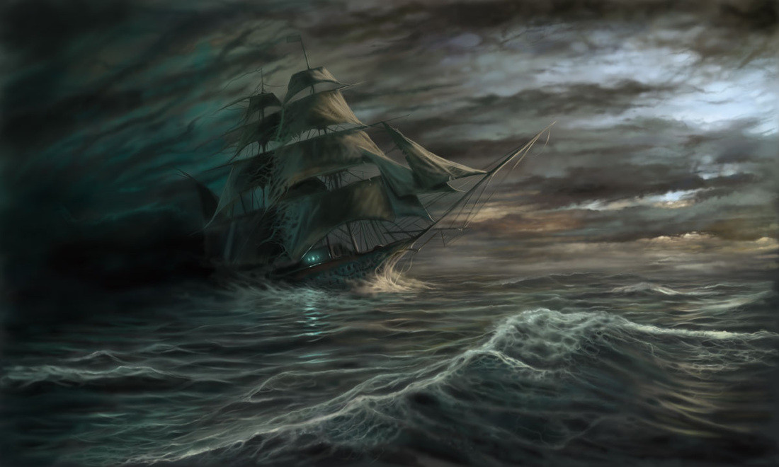
Picture
As some of you know I sometimes share local history on my page as I am a social studies teacher by trade.  Over past years I discovered through my research many local legends and folktales that I have difficulties filing in any specific genre.  Last year I stopped ignoring these tales and embraced them.  I created a presentation titled "Restless Souls, Curious Creatures, and Other Haunts of the Hudson Valley" and presented it at a local theater around Halloween 2011.  

Today I spent the day at a local school presenting the production to students in celebration of Halloween.  I realized during the presentation today that one of the stories would be a great post for my page tonight, and though it has nothing to do with weather, it is an (hopefully) enjoyable and educational experience for all.  Happy Halloween everyone!

Locals and tourists alike lay eyes upon the Hudson River and awe at the beauty and solace contained within the calm sparkling waters.  Many forget the history of the river before Hudson placed his name on nearly 400 years ago.  

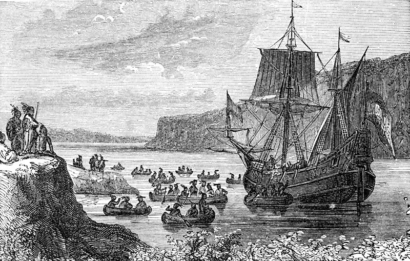
Henry Hudson, the Dutch captain of the Half Moon, ventured up the then named North, Nassau, or Great River in 1609 in search of the Northwest Passage to China.  The river contained beauty much like its appearance today; jagged cliffs and lush trees lined the waters from the mouth of the Atlantic in the south to Lake Tear of the Clouds in the north.  There were no traces of civilization except for small bands of Native Americans visible on the shoreline.

Henry Hudson did not keep a captains log; instead, his first mate, Robert Juet (and future mutineer) kept a journal of the voyage up the picturesque river.  I will share excerpts of his journal to help tell this story.  

On September 12, 1609, the Half Moon anchored not far below the present-day city of Poughkeepsie, and found that canoes full of natives were coming to “betray [the crew of the Half Moon];” however, though the natives were likely wishing to greet the travelers the crew did not allow the natives to board the ship.  Instead they pitched their sails and continued on their way up the river.  The adventure continued as far as it could go before the river quickly became shallow not far above the modern city of Albany.  After trading with the natives and failing to discover a passage west in the Adirondacks the ship sailed south down the river.

On October 1, near the present-day city of Newburgh, the Half Moon met the same group of natives that had wished to betray them on September 12th.  They allowed the group to board in order to trade.  The situation quickly escalated.  

Robert Juet describes the encounter, “This after-noone, one Canoe kept hanging under our sterne with one man in it, which we could not keepe from thence, who got up by our Rudder to the Cabin window, and stole out my Pillow, and two Shirts, and two Bandeleeeres.  Our Masters Mate shot at hime, and [struck] him on the [breast], and killed him.  Whereupon all the rest fled away, some in their Canoes, and some leapt out of them into the water.  Then one of them that swamme got hold of our Boat, thinking to overthrow it.  But our Cooke tooke a Sword, and cut off one of his hands, and he was drowned” (Juet).

After this hostile encounter with the natives the crew was vigilant to any attempt by the locals to board the ship.  On October 2nd “…two Canoes full of men, with their Bowes and Arrowes shot at us after our sterne: in recompence whereof we discharged sixe Muskets, and killed two or three of them.  Then above an hundred of them came to a point of Land to shoot at us.  There I shot a Falcon at them, and killed two of them: whereupon the rest fled into the Woods.  Yet they manned off another Canoe with nine or ten men, which came to meet us.  So I shot at it also a Falcon, and shot it through, and killed one of them.  There our men with their Muskets killed three of foure more of them,” not long after the attacks, the ship had pushed far enough down the river to leave them behind (Juet 207-208).  Finally on that day, the crew reached the Atlantic and began their trip back to Europe.
Picture
We now return to present day to further this story. 397 years after Henry Hudson traveled up the river I was made aware at a local history meeting of a more recent incident relating to the Half Moon.   An elderly gentleman heard that I was researching local history and told me that he experienced something that I would never believe.  The story goes as follows:

This man, which we shall name Samuel, was spending the day fishing on the shore of the Hudson River just north of Highland, NY.  As evening approached he could hear a storm rumbling in the distance.  He gathered his things and began the walk south down the tracks to head home.   

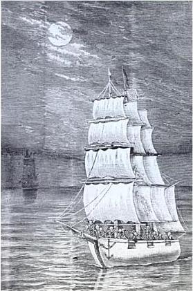
As he wandered he glanced at the river and noticed a ship traveling north near the west shore of the Hudson.  He stopped to watch the ship as it had an appearance that he had never witnessed before.  It was wooden and had three empty masts (no sails).  He told me that it appeared to be an old schooner from yesteryear, something not very common on the Hudson River today.

Slowly the ship approached where he was standing next to the river.  It became apparent that this ship had no crew on the deck.  In fact there was no sound until the ship came within 50 feet of him.  The first thing he heard was creaking, as if the ship was drifting in a heavy sea, but it was not touching the water.  He said it seemed to glide above the surface and did not create a wake.  

Samuel was overcome by awe as the ship methodically floated up the river against the tide.  The storm was coming in fast and he soon lost sight of the schooner in the darkness and the rain.  He did, however, tell me that when the lightning flashed he could see the silhouette of the hull drifting north on the river.   
Picture

Panther Mountain and the Birth of the Catskills

10/12/2012

 
Have you ever wanted to see a giant impact crater from an asteroid but thought you would have to drive thousands of miles to see it?

If your answer is yes just take a drive to Panther Mountain in the Catskills of New York.

Yes, it is a mountain, but it is also part of an asteroid impact crater.  There are a few hills and valleys inside the crater but Panther Mountain is the general identifier.

In the 1970’s a scientist from the New York State Geological Survey (Yngvar Isachsen) was studying an aerial imagery of the Catskills and recognized the following:

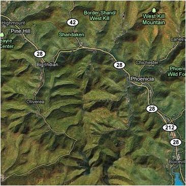
“I first noticed this in the early 1970s," he says. "I had a grant from NASA to study features on this image (see below). See all these squiggly lines? These are valleys formed by streams. That's what you'd expect a valley to look like. All squiggly, going in no particular direction. Now here's where we are. That's the valley formed by the Esopus Creek and its tributary, Woodland Creek. It forms an almost perfect circle around Panther Mountain. So I asked myself, what on Earth would account for that?"

Source: http://discovermagazine.com/2000/aug/featcrater  < this is also a further and in depth read for those of you that are interested.

I would end up finding this the EXACT same way a few years ago just by browsing around the area on Google Earth. 

Can you see it?
Picture
Source: Google Maps
So here is the story behind this crater- it is far more exciting that a rock hitting the dirt in some desert somewhere and creating a hole.

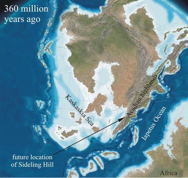
Around 375-400 millions years ago the Catskills did not exist yet.  The GIGANTIC Acadian Mountains were rising where the present day Taconic Mountains line the east side of the Hudson Valley. As the the Acadian Mountains established themselves they began to erode and weather (pieces broke off).

Around the mountains sediment began to pile up.  At the time there was a sea surrounding the Acadians so the sediment stacked up on the shores of the water.  A lot of that sediment was washed down into where the Catskills are today (south-central NY).  The sea that existed at the time, the Kaskaskia Sea, slowly had its western shore moved farther and farther East due to the sediments falling on the shore. 

While this was happening, BOOM, the asteroid hit the Earth right in the sediments on the west edge of the Acadian Mountains.   You can see the Acadian mountain range and the Kaskaskia Sea in this image.  The asteroid struck just about at the tip of the A in "Acadian."
Picture
Source: http://www.nvcc.edu
Eventually the uplift that created the Acadian Mountains ceased and the mountains eroded so much that the area that would be the Catskills became taller than the Acadians.  Some peaks of this "new" mountain range reached 7,000 feet.  Over time the sediments from the Acadian Mountains that washed into the Catskill area turned into solid rock. The weight of the rocks above the crater caused the lower level to fracture and create extremely easy-to-erode joints along the edge.  Think of it as if you were to push down with your hand in fresh cement.  Your hand is the asteroid and the cement is the sediment from the Acadian Mountains.  Once it hardens you would be left with a crater.  Fill the crater with pebbles and sand and then push it down with extreme force.  The sediment (pebbles and sand) would turn into rock.  The edge of where that hand print was will easily break apart if subjected to water.  THAT is what happened with the asteroid crater in the Catskills.

But it still wasn't over...the continents of the Earth collided and huge uplift (rising) took place across the land. 

The “Catskills,” along with much of the Appalachians, became taller than the Himalayas during this collision with Africa and Europe.  The mountains turned into a uniform plateau (flat surface) with only a few peaks.  Streams and creeks began cutting the plateau to form valleys.  Weathering trimmed down the peaks to a height similar to where they are today.

The third and final transformation came with the ice age 15,000 years ago.  Glaciers covered all but probably two peaks in the Catskills (Slide Mountain and West Kill) and ground down their summits and edges.  When the glaciers melted they left multiple lakes that many enjoy visiting today.  Finally the Catskills looked like they do today.

At the base (inside) of one of these Catskill Mountains is the impact crater.  The Esopus Creek slowly eroded away the rocks at the edge of the crater rim (think about the cement example) and cut a perfect circle around the impact crater.  The Esopus follows Route 28 on the map above.  Unknowingly, early settlers settled down around the giant crater because they were following the river for water and food. 

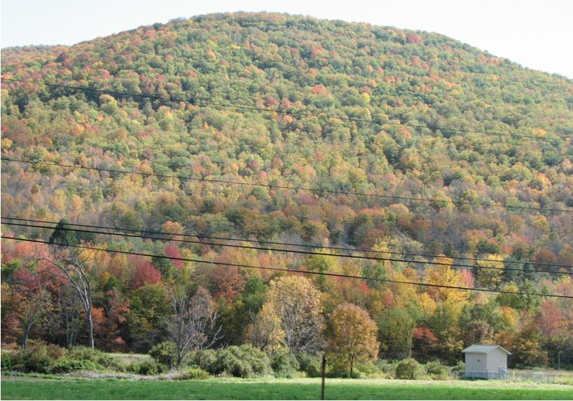
I live near this crater and you do not realize it is a crater at all by driving around it.  It simply looks like a beautiful sloping mountain.  The reality is that deep beneath the mountains there is a huge hole that probably has remnants of the asteroid that struck hundreds of millions of years ago. 

My guess, and this is entirely a guess, is that in the future (100 millions years from now) the Catskill Mountains will erode to the point that the original impact crater is exposed until, again, deposition and erosion creates either a plain over the crater or a new mountain range.

Here is a photo of a part of Panther Mountain that I took in 2009:
Picture
As you can see it does not look anything like a crater; however, I promise you, an impact crater that is 375 million years old sits beneath this beautiful piece of geography just waiting to be exposed to the air once again. 

The Mariana Trench

9/25/2012

 
Picture
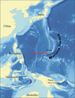
The Mariana Trench. Image: Wikimedia
We all know the Mariana Trench is the deepest spot in all the oceans of the Earth.  It was discovered in 1875 by the H.M.S. Challenger using sounding equipment.  In 1951 it was sounded again by the H.M.S. Challenger II and the deepest part of the ocean was named Challenger Deep.  The trench is just over 36,200 feet deep. 

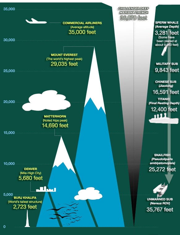
It’s difficult to put that into perspective.  If you had a building with 3,620 stories (each story 10 feet tall) it would represent the depth of the trench.  The tallest building in the world (in Dubai)  measures 2,717 feet and has 160 floors.  It would take over 13 of those buildings in Dubai stacked on top of one another just to reach the depth of the Mariana Trench.  Mount Everest is only 29,000+ feet tall (but is growing all the time, I’ll explain that another time).  The Trench is 1,580 miles long, or almost the distance from New York City to Denver, Colorado.  To get an idea of how deep the Trench is please check out this graphic: 


Picture
Trench Comparison. The depth of the Trench is 36,070 feet in this image but my research shows over 36,200. Image: Florida News Journal
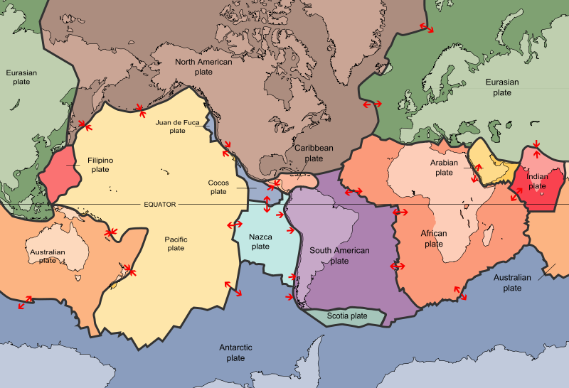
How did the Trench form?  The Trench is actually the product of plate tectonics.  The theory of plate tectonics is as follows: The Earth’s crust is divided into plates that float around on top of molten rock in the lithosphere.  These plates collide and separate all over the place.  Here’s a diagram of the plates on the Earth: 
Picture
Plates of the Earth. Image: Wikimedia
The Pacific Plate is pushing into the Philippine Plate in the western Pacific Ocean.  Oceanic plates are usually made of the rock type basalt. In many cases it is an oceanic plate sliding under (or subducting) beneath a continental plate (made of granite). 

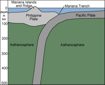
In the case of the Trench it is two oceanic plates colliding.  Due to the fact that the Philippine Plate is older and more dense it stays on top as the Pacific Plate slides underneath it.  A dip in the crust forms where the one plate dives under the other.  This dip, which is just a slight dent in terms of the Earth as a whole, is the Mariana Trench.  See this graphic for a better idea of what I’m talking about: 
Picture
The Mariana Trench is formed by the Pacific Plate subducting under the Philippine Plate. Click image for source.
As the Pacific Plate subducts father into the Earth it begins to melt.  This molten rock is less dense and rises to the surface creating islands and volcanoes in the Philippine Plate.  You can see that area of islands and volcanoes in the diagram above.  It is labeled as the Mariana Islands.  The volcanoes on the northwest coast of the United States are created in this same fashion.  In fact, the volcanoes around the entire Pacific Rim are created by this process.

Anyway, back to the Trench.  The pressure at the bottom is immense.  If you were at the bottom the pressure you'd feel would be created by the weight of the ocean on top of you.  Ever feel pressure changes in the deep end of the pool when you dive to the bottom?  It’s caused by the pool water pushing down on you.  Well there is 15,750 psi at the bottom of the Trench.  That’s 15,750 POUNDS of force on every inch of your body.  This is over 1,000 times the atmospheric pressure at sea level.  Even water is denser because it’s compacted due to the weight above it.  The water temperature is just above freezing.  Basically, it’s not a place you want to visit. 

Life in the Trench goes on as it does on the surface of the Earth.  Many different aquatic life forms live down there.  Thermal vents heat the surrounding water to over 500 degrees while water away from the vents is near freezing.  The vents also disperse minerals into the water to make it suitable for life.  Many critters feed on carcasses of animals that sink from the top of the ocean down into the trench. 

So you would think that, because the trench is so deep, that Challenger Deep is the closest spot to the center of the Earth, right?  Nope! There are actually spots that are closer to the center of the Earth. 

How is this possible? 

Because the Earth is spinning.  Think about a water balloon.  If you were to hang the balloon from a string and spin it like a basketball it would bulge in the center.  The top and bottom of the balloon would move closer to the core of the balloon.  This same concept applies on a much larger scale with the Earth.  The diameter of the Earth when measured on the equator is 7,926.38 miles.  The diameter of the Earth when measured at the poles is 7,899.84 miles.  That’s a difference of 26.54 miles.

Because the Mariana Trench is near the equator it is greatly affected by this equatorial bulge; thus, the trench is not the closest place to the center of the Earth. If you head into the arctic there are some places on the seabed that are much closer than the Trench is to the core. So just remember, you can save yourself 26 miles of travel if you want to go to the core through the poles. 

I hope you found this post interesting and informative.  If you have any questions feel free to ask on my facebook page. 

Information sources:
Mariana Trench by LiveScience
Mariana Trench by Oregon State
An awesome Earth Science teacher by the name of Ann Aleo at Courtland High School in Spotsylvania, Virginia. 


Cassiopeia 

7/11/2012

 
Picture
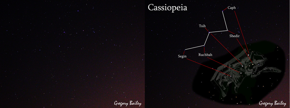
The original exposure is on the left while the labeled image of Cassiopeia is on the right.
Last night before bed I photographed the constellation Cassiopeia.  I was going to just post the photograph of the stars but instead decided to take this post a little further.  As you know in the description of Weather Dork I say I cover all the Earth Sciences.  Astronomy is one part of this field.  Astrology is not part of the Earth Science field; however, I am a Social Studies teacher and love history, as well.  This is one of those opportunities where I can blend my knowledge of science with my knowledge of history to bring you an educational and interesting post on something I love. 

The story behind the name Cassiopeia (courtesy of the Harvard-Smithsonian Center for Astrophysics) is as follows:

Cassiopeia is named after the queen of a country on the northern coast of Africa, Aethiopia (not modern Ethiopia). She boasted that she and her daughter Andromeda were more beautiful than the Nereids, the 50 sea nymph attendants of Thetis, the sea goddess, and Poseidon, the sea god. Thetis, and Poseidon's wife Amphitrite (an alternate sea goddess), were also Nereids, so Cassiopeia's boast was an insult to the gods. The Nereids begged Poseidon to punish Cassiopeia. Poseidon sent a flood carrying a sea monster to destroy the kingdom. Cassiopeia's husband, King Cepheus consulted an oracle, who told him that the only way to appease Poseidon and stop the monster was to sacrifice Andromeda. Andromeda was chained to a sea cliff to be eaten by the monster. She was rescued by the hero Perseus who had seen her chained to the cliff and had fallen instantly in love with her. Perseus was returning from carrying out his oath to kill the Gorgon, Medusa. Perseus offered to kill the sea monster and rescue Andromeda in return for her hand in marriage. Cepheus and Cassiopeia agreed reluctantly. They had already agreed to marry her to Cephus's uncle (his father's twin brother Agenor), and once she had been rescued, they tried to break their promise to Perseus.

Andromeda wanted to keep their promise and insisted that the wedding be held immediately. In some versions of the myth, Cassiopeia summoned Agenor, who rushed into the wedding party with armed men. Perseus fought off a number of them but was greatly outnumbered. He picked up Medusa's head (which he was bringing back as proof that he killed her) and when his attackers looked at it, they turned to stone. Poseidon is supposed to have set images of Cepheus and Cassiopeia in the sky. As a punishment for her treachery, her constellation (a zig-zag shape like an "M" or "W") is supposed to represent Cassiopeia either chained to her throne (in an ironic reference to her daughter's ordeal) or stuffed into a basket. Because the constellation is in a circumpolar position (meaning that it seems to revolve centered around the pole star, Polaris), Cassiopeia is at times suspended upside down in the sky in a very undignified position.

And now for a little science:

Cassiopeia contains five major stars:  Caph, Shedir, Tsih, Ruchbah, and Segin.  These stars make up the “M” or “W” that you see in the constellation.  These stars are all different distances from Earth. 

Caph:  54 light years

Shedir: 229 light years

Tsih: 613 light years

Ruchbah: 99 light years

Segin: 442 light years

To put this into perspective for those that don’t understand what light year means look at it this way:  If Caph were to explode RIGHT NOW we would not know for 54 years.  Another way to look at it is like this:  You build a spaceship able to travel at the speed of light (186,000 MILES PER SECOND) and start flying toward Caph.  It will take 54 years to get there. 

Within the constellation there are two stars that are extremely rare yellow hypergiants.  Yellow hypergiants are massive stars that are 20-50 times the mass of our Sun.  These stars consume nuclear fuel extremely fast and therefore only remain as “stars” for a few million years.  Once the stars run out of fuel they destroy themselves in supernovas or hypernovas. 

Cassiopeia is not alone in the sky.  Some of related and notable constellations surrounding her are the constellations Cepheus (her husband), Perseus (the demigod warrior), Andromeda (her daughter), and Pegasus (the flying horse).

Thanks for reading! I hope you were able to learn something.

1794 Mid-Hudson Valley Tornado

6/19/2012

 
Picture
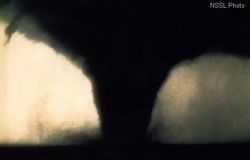
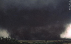
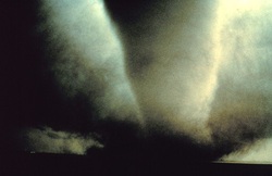
On June 19, 1794 a violent and powerful weather system brought severe weather to the northeast United States.  In the Hudson Valley a large tornado roared across the Hudson River and into Poughkeepsie.  It did extensive damage as it roared across Dutchess County into Connecticut.  I have not been able to find a rating of the tornado as it was before modern weather measurements; however, from what I can tell from the descriptions it had to be at least an EF3 tornado. 

The following excerpts are from individuals that witnessed the tornado in 1794.  The language is archaic but captivating to read.  These primary sources offer us a view into the terror and chaos that this storm created in the area. 


Picture
Photo of a large tornado.

The most terrible wind that had been experienced in western Connecticut since its first settlement passed over a portion of the country at about five o'clock on the afternoon of Thursday, June 19, 1794. Its general direction was from the northwest to the southeast. It first appeared in Poughkeepsie, N. Y., where it blew down several buildings, and destroyed other property. In Connecticut it passed through the towns of New Milford, Newtown, Watertown, Waterbury, Northford and Branford.

Before anything unusual appeared in the heavens a peculiar sound was heard in a westerly direction. After the noise had continued for several minutes a dense, dark cloud appeared over the hills. As it approached it seemed like an immense body of smoke or fog, and at length it was discovered to be in a state of extreme agitation, wreathing in and out and whirling in the most furious manner. The foremost part of the cloud had the appearance of a common thunder cloud, being thick and heavy, but not very dark. Its height and width were about an eighth of a mile either way. We have said its width, but diameter would be more correct as the cloud was round. It whirled along like a cylinder revolving perpendicularly. Those who saw it directly in front, and only six or eight rods away, said that innumerable streaks of fire ran across it in every direction, and at a distance the cloud seemed to lighten up now and then. It was supposed by some people at the time that the light was due to friction caused by the articles that were revolving with great rapidity in the vortex of the cloud, among which were the herbage of the field, parts of fences, leaves, boughs and trunks of trees, boards, doors, barrels, clothing, live geese and other fowls and birds. The centre of the cloud was clear air. At Northford it seemed to divide into several smaller whirlwinds, yet forming one complete cylinder of air and cloud. The vortex contracted and increased in diameter at several periods of its progress. When it contracted its force seemed to lessen, and as it grew larger it became correspondingly more frightful and disastrous.

Its course was irregular, and it travelled with great rapidity and in the wildest confusion. Its path, though well defined, greatly varied in width. It was very narrow on the highlands, but when the cylinder of cloud and whirling wind descended a hill it seemed to spread out like a flood of waters rushing down with a velocity that constantly increased, and became quite wide when it reached the valley. As it approached, the noise became louder until it rumbled like the roar of an earthquake. Those persons who were carried up by the wind into the cloud and yet escaped with their lives said that it was as dark as night during the three or four minutes they were in it, and that the noise was deafening and awful. Those who were quite near- it, and yet escaped said that it appeared to them most fearful and sublime. After the column of wind had passed by, a little rain fell from the rear end of the cloud, accompanied by a small amount of hail.

The destruction occasioned by the wind was most disastrous, many houses, barns, and other buildings being blown to pieces, a number of cattle killed, and several human lives lost. Orchards and forests yielded to its irresistible power, and strong oaks, sturdy maples and elastic walnuts were torn up by the roots or twisted off leaving stumps from three to fifteen feet in height. Every fence and stone wall in its course was demolished.

On either side of the path of the whirlwind the air was calm. An incident showing this is thus related. A gentleman was quietly sitting in the stoop of his house, unconscious that such a terrible messenger of destruction was so near him, when without feeling the force of the wind in the least, he was amazed to see his bam, which stood but about four rods from his house, lifted up and moved off its foundations.

At New Milford, the whirlwind came into the town on the northwest side and passed through in a southeasterly direction. Fortunately its course lay just outside the village, as it there encountered, few dwelling houses and other buildings. It made broad paths through extensive tracts of woodland, that were visible as far as the eye could reach. Timber trees of various kinds and sizes and of great strength were prostrated, being broken down or torn out of the ground by the roots. A few cattle were killed by falling trees and timbers from demolished barns. Three houses were wholly destroyed, and twelve were unroofed and much shattered. Eight barns were snatched from their foundations and torn to pieces.

Benjamin Stone, jr., saw the cloud approaching, and being aware of its terrible import, he took his four children (his wife being away from home) and hurried to his new, strong barn, which he thought would withstand the wind. The building was but a few rods away, and they had time to reach the bay in it before the whirlwind struck the place. But Mr. Stone was wrong in his estimate of the wind's force, the barn tipped over, and he and the children were carried under the sills into the yard, amid timbers and fragments of trees that were moving hither and thither in great confusion. They escaped, however, with only slight wounds. Mr. Stone's house was stripped of all its shingles, clapboards, boards and windows, leaving the frame bare, and several of the timbers were also scattered about. All the contents of the house above the lower floor,- furniture, clothing, and provisions, were carried away, scarcely anything being found that was still whole, and many of the articles were never seen again. A purse containing sixteen dollars, that was kept in a case of drawers was found eight or ten rods away. The residence of Thaddeus Cole was torn into fragments. When the whirlwind struck the house there were in it Mrs. Cole and her infant child, and a Mr. Tucker, who were all buried in the ruins. The neighbors discovered their condition, and with willing hands they hurried to relieve them, but an hour elapsed before they could be extricated. The child was found dead, having been killed in its mother's arms, Mrs. Cole was greatly bruised, and Mr. Tucker was so severely injured that for a long time it was supposed he could not recover.

John Carpenter was in a field with five or six hired men and two of his sons, one of whom was eleven years old, and they were suddenly overtaken by the whirlwind. They immediately fell on their faces, and, grasping the herbage of the field, clung to it while the furious wind repeatedly raised their bodies up and let them fall upon the ground, bruising them considerably. Fence rails and parts of trees fell thickly about them. Mr. Carpenter was wounded in his back by a rail, and his younger son had his head beaten two inches into the ground, almost mortally wounding him. Mr. Carpenter's horse was whirled into the air, being carried twelve rods up a steep hill, where he struck with so much force that his body indented the ground to the depth of five or six inches. He was then whirled back, nearly the same distance, being found dead at about the same place where he was first attacked by the terrible wind. Another horse, that was hitched to a post, was carried over a stone wall into a field of wheat, a distance of forty or fifty rods. A new ox-cart was completely broken into pieces, which were scattered in all directions. One of the wheels with the axle-tree was found about three rods away, and the other wheel was carried two or three rods further, being forced some distance into the ground. The body of the cart was found four or five rods farther away and an iron washer that had belonged to it had been carried a rod or two beyond. The water in a large brook was also taken up and distributed over an adjoining field. Several large trees were carried from thirty to sixty rods. A hackmatack, or tamarac, tree was taken up by the roots, and carried along in its natural position. At times it would descend nearly to the earth, then rise with great rapidity to the height of some three hundred feet. Appearing to play around it were two or three large objects that were supposed by the people who witnessed the scene to be barn doors. They attended the tree in all its evolutions until it disappeared from sight. One barn door was found eight or ten miles from the place where it was snatched up by the wind. A heavy oak log, fifty feet long, and nine inches in diameter at the small end, was lying on the lower side of a road which ran along the slope of a steep hill, and a smaller log lay on one end of it. The two logs were taken up by the wind and carried to the other side of the road. At Newtown, several houses and barns were blown down, and its effects were also severely felt in Watertown and Waterbury. In Northford, the whirlwind providentially passed over a portion of the town that had but a scattering population, and therefore did not destroy many buildings or injure any persons in its course. Several buildings were however removed from their foundations, and some were torn to pieces. It did considerable damage in the destruction of forest and fruit trees, and sugar maples. It was also felt at Branford, and probably ended its disastrous career on the Sound.

Source:  Historic Storms of New England by Sidney Perley, 1891

Picture
On Thursday afternoon, 19th inst. passed over this place a cloud out of the S.W. the head of which was very thick and heavy, like the common thunder cloud; but of a very light smoky colour and agitated beyond description. It’s height and diametrical extent about one eighth of a mile; of a circular figure, whirling in a most violent manner from its center. From its center issued a vortex of air, (similar to what is often seen in water) which descended to the earth, and alternately increased from 1 to 2 rods apparently, but really from 5 to 20. As I stood and viewed it, at times it appeared to divide into a number of whirls, yet all complete in one. This vortex had constant communication with the cloud above, and when it contracted (the vortex) the wind lulled a little, but when it expanded, frightful to behold!

The herbage of the field, the fowls of heaven, fences, leaves, boughs and trunks of trees filled the atmosphere, and whirled in every direction. No rain or hail fell from it; zigzag in its coarse attended with an alarming rumbling something like that of an earthquake. A providencial circumstance! It did not take many buildings in its course, those which it did were moved from their foundations; prostrated to the ground or wrenched asunder and whirled at a distance. The lowest ground was marked with the greatest havock; there the sturdy oak; the stubborn maple; the classic walnut were twisted off or torn up by the roots. Orchards and forests yielded to its violence. The damage and destruction of buildings and fences is considerable, but the greatest loss sustained is in fruit-trees and sugar-maples; one gentleman lost forty-five very valuable apple-trees; another a number of apple trees and forty or fifty maples. Damage and devastation were the uniform marks of its progress. The place of its first and last appearance I have not been able to learn; on each side of it all was calm. A gentleman set in his stoop and felt nothing of it, at the same instant he saw his barn (about four rods off) rise and move a small distance from its foundation.

Source: Windham Herald 5 July 1794

The Manson Crater

4/11/2012

 
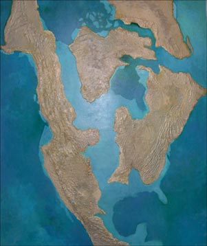
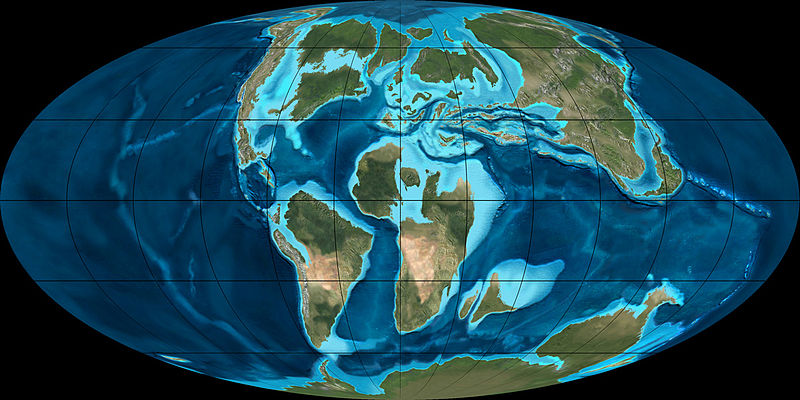
74 million years ago North America looked A LOT different! The crust of the Earth is broken into multiple “plates” that are driven by the heat and pressure from within the Earth.  The plates collide and pull apart every minute of every day in a process called plate tectonics.  It takes millions of years for any noticeable change to occur in the shape of the continents; however, almost every earthquake on Earth is caused by this violent splitting and crashing of the plates into one another. Below you can find images of what the Earth looked like at this time in history.
Picture
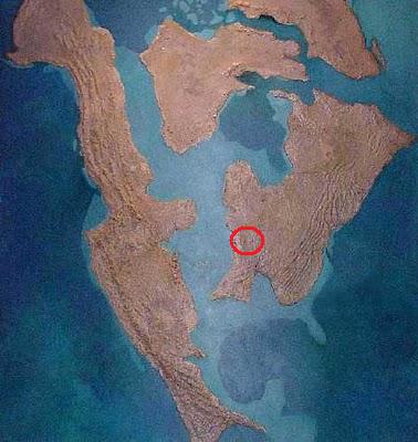
Here is (roughly) what North America looked like 70 million years ago. Image: Everything Dinosaur
Picture
Here is a view of what the entire Earth looked like around the same time. Image: Wikipedia
75-70 million years ago falls within the Cretaceous period. This was a time of relatively warm climate, resulting in high sea levels and creating numerous shallow inland seas. These oceans and seas were populated with now extinct marine reptiles while dinosaurs continued to dominate on land.  There were new groups of mammals and birds and plants that appeared. The Cretaceous ended with a large mass extinction (the asteroid that killed off the dinosaurs) 65 million years ago. 

Now that we have the setting let us get to the "meat" of this blog post!  In the area that is now the state of Iowa in North America a large asteroid struck the Earth.  The impact was equivalent to 1,000,000 Hiroshima nuclear bombs, created earthquakes in excess of 10.0 magnitude, and generated tsunamis hundreds of feet high.  The asteroid dug a mile into the Earth in a fraction of a second and formed a crater about 24 miles in diameter.  “The impact is said to equal 10 trillion tons of TNT, resulting in an electromagnetic blast that incinerated anything within 130 miles and wiped out all life within 650 miles of the blast” (Pfeiffer).  In fact scientists once believed that this asteroid impact may have been the culprit that wiped out the dinosaurs.  Of course, we now know (at least we are pretty sure) that the asteroid that wiped out the dinosaurs struck 65 million years ago. 
Picture
The circled area is the approximate region of Iowa and of the meteor impact.
Over time the crater eroded and glacial till covered it completely.  Today the area above the crater is completely flat; however, dozens of feet beneath the soil sits a giant crater and remnants of a meteorite.  The meteor was most likely 1.2 miles wide, made of stone, and was traveling 45,000mph when it struck the Earth. 
Today the town of Manson, Iowa sits on top of the crater.  For years engineers looked for a sustainable water source beneath the ground in Iowa.  The Iowa Department of Natural Resources thinks it knows how to find this sustainable water source:  When the meteor struck the Earth it instantly vaporized and pulverized the limestone in the ground beneath the impact. 

All of the limestone that was pulverized was able to mix with the groundwater deep underground and create the only natural soft water source in Iowa.  Engineers want to tap into this massive area soft water under the ground and they believe the softest of the water is located in the center of the crater.  Plans are being put together to drill into the center of the crater in hopes of creating a soft water well to supply Manson and neighboring Iowa towns with fresh water. 
Picture
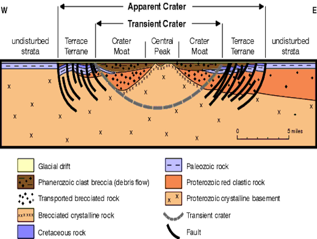
Here is a cross section of the underground crater. Image: IowaDNR
The task will not be simple, however.  Unless the exact center of the crater can be located there will be multiple attempts to find the softest of the water and multiple failures.  It may also prove to be difficult to drill through the rock layers outside of the crater center due to folding and faulting from the impact.

Hopefully engineers and scientists succeed and, in the process, gather more scientific evidence regarding the meteor and the massive impact it had on Cretaceous North America.  

Thanks for reading!

Sources:

http://www.igsb.uiowa.edu/browse/manson99/manson.htm

http://news.yahoo.com/blogs/sideshow/ancient-meteor-standing-between-one-iowa-town-water-154639667.html

http://blog.everythingdinosaur.co.uk/blog/_archives/2010/04/23/4512087.html

Our Violent Star

3/7/2012

 
On the eve of arrival for a massive X-class solar flare I feel it is appropriate to write a blog regarding what solar flares are and how the affect our planet. 

To understand solar flares we must understand how the Sun works.  

The Sun is a giant fusion reactor.  The core of the Sun is 27 MILLION degrees fahrenheit, partly due to the giant pressure created by the gravity pulling all the mass to the center. At this extreme temperature and pressure the process of fusion can take place.  Fusion, or the process of combining two separate things into one, is not only what lights up the Sun but also gives the Earth light and heat.  To put it plainly two hydrogen atoms are fused to create one helium atom.  The helium atoms are less massive than the two hydrogen atoms that began the process; because of this, according to Einstein’s theory of relativity, the loss of mass means that it has to be converted to energy (E=mc2).  The energy created by this process is emitted as many forms of light: ultraviolet, X-rays, infrared, visible, radio waves, and microwaves. 

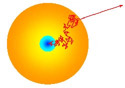
The core of the Sun is so dense that it takes energy created by fusion anywhere from 100,000 years to 50 million years to reach the SURFACE of the sun.  From that point on it only takes 8 MINUTES to reach the Earth.  

Picture
Light escapes the sun's core through a series of random steps as it is absorbed and emitted by atoms along the way. Image: http://sunearthday.gsfc.nasa.gov/2007/locations/ttt_sunlight.php
So that is how the Sun creates its energy but why does it burp it up sometimes?  The burp, mind you, is a solar flare and coronal mass ejection (CME). 

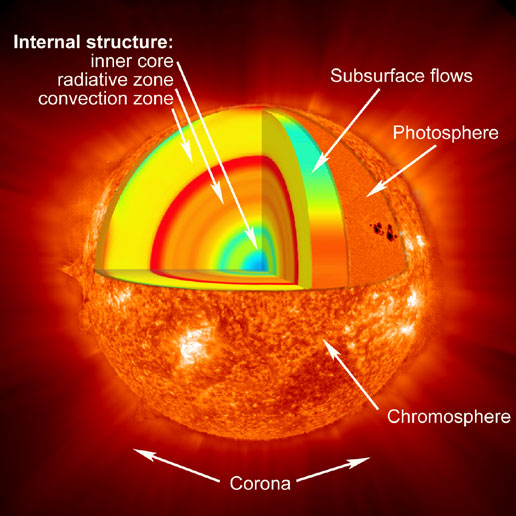
We have to start with the solar atmosphere, or the atmosphere of the Sun.  The Sun’s atmosphere is actually a giant magnetic hodgepodge of energy and power.  It is said to be made up of the Chromosphere, Photosphere, and Corona.   See the image below to better understand the Sun’s layers.  

Picture
Image: http://www.nasa.gov/images/content/171925main_heliolayers_label_516.jpg
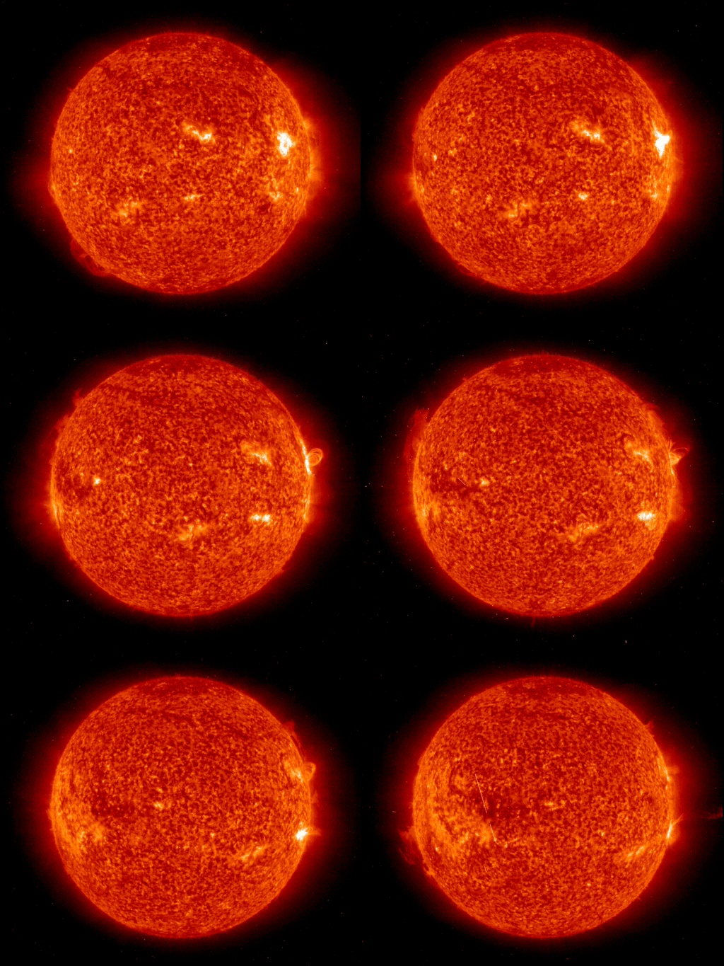
As mentioned before, the atmosphere of the Sun is EXTREMELY unstable.  All the energy and heat being created in the core allows for massive magnetic shifts on the surface and near the surface.  Look at this image below. 

Picture
Image: http://cache.boston.com/universal/site_graphics/blogs/bigpicture/sol_10_13/sol09.gif
You can see the prominences, or large loops of gas and particles, being held in by the magnetic field of the Sun.  Meanwhile the surface bubbles with giant grains of plasma floating at the surface.   In many cases the energy from the core is bottled up in the atmosphere until it can no longer be contained by the magnetic field and a CME results.  The CME rushes outward and follows the solar wind, which is always present, but is not a wind as we know it; the solar wind is a steady stream of charged particles emitted from the Sun.  When the solar wind hits the magnetosphere of the Earth northern latitudes see northern lights.  When a CME hits the magnetosphere of the Earth middle and lower latitudes may see northern lights.

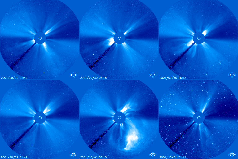
Look at the animation below of a CME taking place.  The large disk in the middle is used to block out the Sun so the Corona is visible.  

Picture
Notice the steady solar wind coming off the Sun at all times. The large explosion is the CME. The streaks at the end are caused by radiation hitting the satellite. Image: http://upload.wikimedia.org/wikipedia/commons/3/37/LASCO20011001.gif
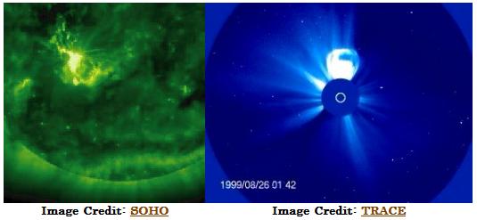
So what is the difference between a CME and a solar flare?  The best description I have seen comes from a science page a Berkley: “The most obvious difference between a solar flare and a CME is the spatial scale on which they occur. Flares are local events as compared to CMEs which are much larger eruptions of the corona.”
Picture
“The left image above shows a bright solar flare erupting in an active region on the Sun. The image on the right shows a CME exploding off the Sun. Notice that this CME is even larger than the Sun itself, which is represented by the white circle in the middle of the frame. Solar flares and coronal mass ejections often occur together, but each can also take place in the absence of the other.”

Solar Flares:

Solar flares occur when large amounts of energy explode in the solar atmosphere and heat the surrounding area to millions of degrees.  This process may take a few seconds or a few minutes.  Flares have the energy equivalent of 160,000,000 megatons of TNT.   They accelerate particles into space and appear to us as bright lights on the surface of the Sun.   When these flares are directed toward Earth we usually receive the energy in a couple days.  Solar flares are classified based on their x-ray intensity.  A, B, C, M, X are the classifications.  The latest flare is an X-class flare, the largest. 

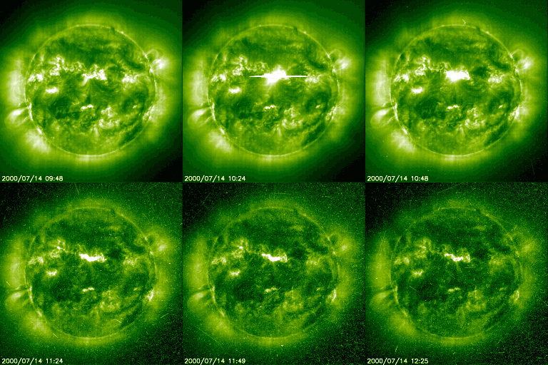
Solar flares typically occur near sunspots, or areas of the sun that are cooler.  Since the sunspots are cooler the magnetic field is concentrated to those areas causing the Sun to become unstable.  Solar flares move near the speed of light and Earth has little time to prepare for their arrival.  Astronauts are bombarded with increased radiation when these events occur because they do not have a magnetic field to protect them like the Earth does.    See the image below for a representation of a solar flare.  

Picture
Image: http://science.nasa.gov/media/medialibrary/2000/07/14/ast14jul_2m_resources/flare_eit195_big.gif
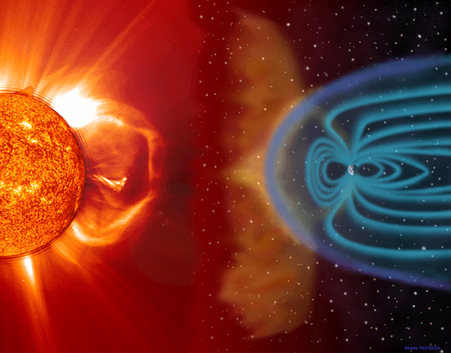
When all these particles reach the Earth they hit a brick wall, the magnetic field, and most are sent past Earth and into space.  The rest of the particles are sent into the magnetic field.  This is called a geomagnetic storm.  The epic battle of the magnetic field against the charged particles results in an aurora.  If a storm is large, you can expect a powerful aurora that reaches into the U.S.  The South Pole has its own aurora, too! 

Picture
Notice the magnetic field around the Earth. When particles hit the Earth the lines in the field bounce and stretch to deflect and absorb the charged particles. Image: http://solar.physics.montana.edu/coradett/images/sunearth_01G.gif
What happens to electronics and infrastructure when the charged particles hit the Earth?  This is from NOAA and depicts what occurs when the strongest of geomagnetic storms develop on the Earth:

Power systems: widespread voltage control problems and protective system problems can occur, some grid systems may experience complete collapse or blackouts. Transformers may experience damage. 

Spacecraft operations: may experience extensive surface charging, problems with orientation, uplink/downlink and tracking satellites. 

Other systems: pipeline currents can reach hundreds of amps, HF (high frequency) radio propagation may be impossible in many areas for one to two days, satellite navigation may be degraded for days, low-frequency radio navigation can be out for hours, and aurora has been seen as low as Florida and southern Texas (typically 40° geomagnetic lat.)**.

Each geomagnetic storm has its own classification and power.  To see the other levels of the scale please visit:  http://www.swpc.noaa.gov/NOAAscales/ I feel like we should review before I wrap this up considering how complex this blog is:
  1. The Sun creates heat and light in its core through the process of fusion.  
  2. It takes 100,000-50,000,000 years for the light to reach the surface of the sun.
  3. The light takes 8 minutes to reach Earth.  
  4. When large amounts of energy explode from the Sun this is called a solar flare.  
  5. Solar flare energy moves near the speed of light to Earth and arrives in minutes.
  6. Many times solar flares lead to CME's, which are large explosions of charged particles.  
  7. These CME's follow the solar wind and bombard the Earth to create aurora.  
  8. Aurora are pretty to look at but can be dangerous.  Blackouts are possible when large amounts of radiation hit the Earth.
Conclusion:  The Sun is enormously complex and this blog, I feel, only touches the "surface" of the Sun.  The descriptions of the fusion, CME’s, flares, and aurora are watered down for the sake of understanding.  Even I have trouble understanding the complexity!  As always if you have any questions please let me know.  Thanks for reading.  

Sources:
  • http://sunearthday.gsfc.nasa.gov/2007/locations/ttt_sunlight.php
  • http://hesperia.gsfc.nasa.gov/sftheory/flare.htm
  • http://www.enchantedlearning.com/subjects/astronomy/sun/prominences.shtml
  • http://image.gsfc.nasa.gov/poetry//workbook/page6.html
  • http://cse.ssl.berkeley.edu/coronalweather/CMEsFlares/index.html
  • http://www.swpc.noaa.gov
<<Previous
Forward>>

    Author

    I am an educator and avid student of Earth sciences and history. 

    Archives

    April 2019
    May 2015
    July 2014
    April 2014
    January 2014
    December 2013
    October 2013
    April 2013
    January 2013
    December 2012
    November 2012
    October 2012
    September 2012
    July 2012
    June 2012
    April 2012
    March 2012
    February 2012
    January 2012

    Categories

    All
    Asteroid
    Astronomy
    Cme
    Earth
    Flare
    Geology
    Ghost
    Global Warming
    Great New York Flood
    Halloween
    Hurricanes
    Ice Dam
    Little Ice Age
    New England
    Northeast
    Optics
    Sun
    Universe
    Volcanoes
    Weather

    RSS Feed

Powered by Create your own unique website with customizable templates.