FIND MY PAGE ON FACEBOOK!!!!!!
The Weather Dork
  • Home
  • Educational Blogs

We know about hurricanes, but what about hypercanes?

3/6/2012

 
Did you know that the Earth has a fever all the time?  This fever is kept in check by ocean and air currents attempting to cool the hot equatorial region of the Earth.  However, the Earth is not very efficient when it comes to lowering this fever through that process because the process itself creates rising and sinking air.  Where air is warm, it rises, where it is cold, it sinks.  

Think about packing an ice chest-  would you put the ice on the bottom of the chest or the top?  If you said the top, you are right.  Cold air sinks thus keeping your food and drinks cool as well. 

It is the same process in the atmosphere (in a way).  The massive circulations on the on Earth are called Hadley Cells… see the following image.
Picture
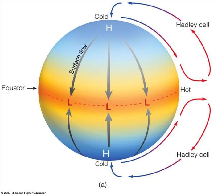
Image depicting a Hadley Cell. Photo: http://apollo.lsc.vsc.edu/classes/met130/notes/chapter10/single_cell.html
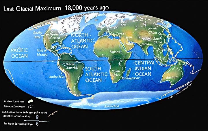
High pressure means air is sinking.  If you go to Antarctica you are actually visiting a desert! I know that seems odd but the central region of Antarctica receives a negligible amount of precipitation a year; however, whatever does fall stays there because it is so cold! The reason Antarctica is a desert is due to the Hadley Cell circulation…low pressure (or rising air and storms) at the equator and sinking air at the poles (or clear skies with no precipitation).  There are more cells in between the equator and the poles but this is the “gist” of the process.
Hurricanes are just one more part of these massive circulation processes on the Earth.  They are the way the atmosphere can fix the disparity between warm and cold, or low and high pressure.  It is always hurricane season somewhere on Earth- it is basically a 365 day conveyor belt of storms coming out of the tropics.  Warm air from the tropics rises into moisture laden air and forms a giant monster that uses an engine of heat from the ocean.  When the hurricane moves into northern or southern latitudes it disperses that heat into the air and water, the air sinks, and the hurricane dies.  If the ocean temperatures are warmer at the tropics and farther north or south, this cycle becomes more violent and persistent.  If the ocean temperatures are cooler at the tropics and farther north or south, the cycle is slower and more spread out. 

Here is a graphic of how a hurricane forms and the typical tracks that they take:

Picture
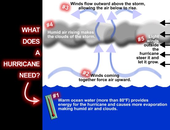
Process involved in making a tropical system. Photo: http://www.weatherwizkids.com/Hurricane_formation.gif
Picture
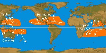
The orange areas in this image represent the areas that tropical systems typically form. The lines and arrows depict the tracks of tropical systems. Notice each track takes hurricanes from the equator to the north or south or, to put it another way, from hot to cold: Photo: http://www.comet.ucar.edu/nsflab/web/hurricane/312.htm
The following section is speculative.  There is no way of proving that this is true or that it did happen; however, science is a matter of speculation and hypothesis.  If the evidence can prove the theory then it is viable.  Please remember this as you read on:  

I did research in college on a theory related to this.  I thought that when the asteroid that killed the dinosaurs struck the Earth it rapidly heated the oceans- especially in the tropical latitudes.  After going through databases and books I found that some scientists investigated this theory and hypothesized that multiple "Mega Hurricanes" formed due to the extremely hot ocean temperatures. 

The water around the region of impact of the asteroid that killed the dinosaurs 65 million years ago superheated to over 120 degrees.  Quickly a huge storm formed over this superheated water, or a hypercane.  Kerry Emanuel of MIT says that when he was playing with his model of hurricanes and typed in a water temperature of over 120 degrees he found that the wind speed of the hurricane became over 500 miles per hour!!! In addition these hurricanes may have been larger than the entire United States! 

Emanuel theorizes that particles from the asteroid impact that killed the dinosaurs are found around the world because of these “hypercanes.”  The hypercanes pulled pieces of the earth high into the atmosphere and distributed them around the world as they tore across the tattered surface.  Another way these giant monster storms can form, according to Emanuel, is through the heating of the ocean from an underwater volcano.

Of course, once the hypercane moved out of the region of superheated water it cooled and turned into a normal hurricane and then just low pressure; still the hypercane cycle continued across the earth until the excessive ocean temperatures equalized (and at that point the entire ocean was warmer).  It is hypothesized that these mega-storms contributed to the extinction of the dinosaurs. 

I no longer have access to the article that I used for this research (it was six  years ago) but I was able to find a shorter version of his theory on this page, if you are interested.

http://alum.mit.edu/pages/sliceofmit/2009/08/14/what-do-you-know-about-hypercanes/

Also, if you want to watch TV’s dramatic cinematic take on the subject please watch this video on YouTube:

http://www.youtube.com/watch?v=JTxj3M3XKcQ

If you have any questions feel free to ask.  Thanks for reading.

The Earth's Crust Needs To Rebound

2/18/2012

 
If you live in the northeast part of the United States, guess what?  We are moving south!

Seriously, the northeast part of the continent that contains the United States is slowly drifting to the south.  Well in reality it is going in many different directions but the overall shift seems to be toward the equator.  See the map below to get an idea of what I am saying. The arrows indicate the direction the crust is moving. 
Picture
This illustration shows horizontal movements of Earth's crust in North America. Larger arrows represent greater annual movement. Source: Eric Calais/ Perdue University
So I am guessing at this point you are wondering how in the world this could be happening? The answer is simple on one level but overwhelmingly complex on another. 

I will give the easy answer first:
The Earth is trying to fix itself after being stepped on for thousands of years. 

And now the more complex answer: 
The last of the massive ice age glaciers, which receded 10,000 years ago, caused the crust of the Earth to compress under their weight. 

Around 110,000 years ago the Earth began to cool and glaciers, or giant and slow moving flows of ice that are created by compacted snow on sides of mountains, took over a huge amount of real estate in the northern hemisphere.  See the map below to understand the extent of the ice sheet that originated at the north pole of the Earth. 
Picture
Glacial Maximum. This map represents the reach of the glaciers during the last Ice age in the Northern Hemisphere. Notice the large ice sheet over the northeast of the United States. Source: http://www.scotese.com/
As you can see the glaciers reached their maximum around 18,000 years ago.  Soon after this glacial max a period of warming caused the ice sheet to melt and recede back into the northern part of the hemisphere where it remains (especially in Greenland) today.

Specifically where I live in the Hudson Valley we had the Laurentide Ice Sheet.  Well over a mile of ice was stacked right over where I am sitting while I write this blog!   “The Laurentide ice sheet advanced and retreated over a period of 60,000 years. The last advance reached maximum 22,000 years ago, extending from southeastern Alberta across what are now the Great Lakes to the east coast” (New York Nature).  The Hudson Valley itself was created by the epic forces glaciers exerted to carve out the land beneath them.  In fact there were four different advances and retreats of glaciers during this time in the Hudson Valley.

Each time the glaciers advanced the pushed out the topsoil beneath them.  Ever wonder why New Jersey is called the Garden State?  It is because the glaciers took all of New York’s good topsoil for growing!

The glaciers picked up and pushed the soil to the south and in return deposited the large boulders and stones (glacial till) that we have in the Hudson Valley.  Trying to dig a hole is an hour long process where I live in Ulster County because of the amount of rocks deposited by the ice sheet. 

The glaciers did more than drop rocks and crush the Earth.  During the last ice age the present form of the Hudson River was carved out.  “Near Storm King, there is a place on the Hudson River bed that is nearly 200 feet below sea level. When the glaciers melted and the sea level rose back to normal, these streams and rivers flooded with sea water. The Hudson is in certain places like Norwegian fjords, drowned valleys” (Watertrail). 

I would love to give a number for how much glaciers weigh but after researching I cannot seem to find anything.  What I can tell you is that the pounds per square inch beneath the glacier were most likely in the thousands. 

Some may think that the Earth is too large to be dented but that is not the case at all.  The Laurentide Ice Sheet was so heavy that it crushed the crust and caused it to sag into the mantle!  When the ice melted the crust had to regain its former shape. 

Think of crushing a plastic bottle with your hands.  Your hands are the glaciers and the bottle is the Earth’s crust.  When you remove your hands some areas of the bottle spring back right away simply because there is no longer any pressure.  The other parts of the bottle do not spring back so quickly.  To fix this you have to blow into the bottle to make it pop back into place.   You blowing into the bottle represents the heat and pressure that is pushed onto the bottom of the crust by the liquid mantle inside the Earth.  When the glaciers pushed down the crust beneath them the liquid mantle was pushed out of the way by the weight of the crust above.

If you need to see a visual animation of this process to better understand it please go here. 

Let us go back to the beginning of this blog and return to the original topic- the northeast of the United States moving south.  If you have not been able to figure out why it is moving south, that is okay, because it took me a while to figure it out, too! The reality is the continent is rebounding, even today, since the glaciers left.

Scientists knew about “post-glacial rebound” for years before the measurements presented the fact that the northeast is shifting south.  They were baffled to see this result and immediately tried to explain it. The answer?  It has everything to do with the rebounding process. 

The continent is stretching horizontally as it bounces back from the compression process.  “It turns out this slow recovery is also causing a very small horizontal shift, said Eric Calais, a geophysicist at Purdue University in Indiana. The movement varies from one spot to another, but the overall effect amounts to a 1-millimeter shortening per year of the distance between Florida and the Hudson Bay in northeastern Canada. That's about an inch every 25 years” (MSNBC). 

If you had a balloon and pushed it against the wall it would have to stretch out sideways.  That process is the same one that is happening to the crust.  It is stretching sideways as it is pushed from beneath.

This rebound is not exactly a subtle process.  Many of the smaller earthquakes that occur in the northeast United States are caused by the crust trying to fix itself.  Here is a map of earthquakes in New York from 1990-2006 from the USGS.
Picture
Seismicity of New York (1990-2006). Notice the smaller earthquakes in the center of the state. Source: USGS
The earthquakes around New York City and northern New York were most likely caused by faults, not by glacial rebound.  However the smaller earthquakes across the state were probably caused by the crust suddenly moving as it relaxes. 

In May of last year Maine suffered dozens of microquakes within a matter of days. “All the quakes measured below magnitude 2, and many were too small to feel. Early notification came from residents’ calls to local authorities, reporting the sound of gunshots and unexpected blasting. It was actually the sound of Earth’s crust moving” (Wired). 

When the glacier was sitting on the northeast U.S. the crust was pushed down 500 feet! 

Let me put this in perspective:  My elevation is 155 feet above sea level.  If the glacier was sitting on top of the crust where I am right now I would be below sea level.  If we somehow removed the glacier quickly and allowed the water from the ocean to flow in I would be under the Atlantic Ocean right now!

Conclusion:

The last glaciers in the northeast melted thousands of years ago.  This is a blink of the eye in geological time. The rebound process will continue for hundreds if not thousands of years to come.  The earthquakes will not be huge (over 4.0M) but I can guarantee that there will be hundreds of headlines over the next millennia as the Earth tries to heal the damage that the glaciers caused to the crust. 

Of course if another ice age comes along the crust will have to deal with this ALL over again. 

Don’t worry, though, Earth is used to it.   :-)

Thanks for reading!

- The Weather Dork

Sources:
http://watertrail.org/geology/
http://www.scotese.com
http://www.wired.com/wiredscience/2011/05/maine-earthquakes/
http://www.msnbc.msn.com/id/10498900/ns/technology_and_science-science/t/northeast-moving-south/
http://www.newyorknature.net/IceAge.html
http://www.fccj.info/gly1001/animations/Chapter6/GlacialIsostasy.html
http://www.geo.hunter.cuny.edu/bight/coast.html
http://www.usgs.gov

The Constellation Orion and Blue and Red Supergiants.

2/2/2012

 
Last night I posted on Weather Dork an exposure of the night sky in Highland, NY.  See the image below.  
Picture
Notice the constellation Orion in the upper right hand part of the image. The streaks coming off the stars were caused by a movement of the lens when I took the photograph.
Having trouble seeing it?  It's okay! Here is a more detailed image of Orion, or, The Hunter.  
Picture
This is the constellation Orion with the outlined shape. Notice his belt, the three stars, in the center. Source: http://www.pa.msu.edu/
Orion has been acknowledged by different cultures around the world for thousands of years.  It is one of the most noticeable constellations in the sky due in part to the very thing that makes him famous, Orion's Belt.  

The belt is made up of three individual stars: Alnitak, Alnilam, and Mintaka.  The three stars look like they are right next to one another, right?  I know it may look this way but in reality they are many many light years (or the distance it takes to travel at the speed of light in one year) away from one another.  

Think of it this way.  You are sitting at a table and have three grapes sitting in front of you.  You take the first grape and put it one foot away from you on the table.  The next you put two feet away from you and just to the right of the first.  The final grape you set on the edge of the table on the other side and again just to the right of the other two.  Then, you kneel down and look at the grapes at eye level.  They look like they are right next to one another but in reality they are spread out over a distance.  This is the concept with the three stars that make up Orion's Belt.  

But this blog is not about Orion's Belt, it is about the two massive stars that stand out in it: Rigel and Betelgeuse.  

Let's look at a photo of the two stars to help us understand where they are in the constellation:  

Picture
Notice Betelgeuse and Rigel circled. Compare this photo to the first one in this blog and you can see the red tint of Betelgeuse and blue tint of Rigel. Source: http://ottawa-rasc.ca
Let's start with Rigel, the smallest of two:

Rigel is the brightest star in the constellation Orion and one of the brightest stars in the night sky.  It is around 850 light years away, or, if you were traveling at 700,000,000mph it would still take 850 years to get to Rigel from Earth.  Earthsky.org puts this in perspective, "In other words, the light you may see from Rigel some spring or winter night, started on its journey at least 250 years before Columbus sailed across the Atlantic!"

The star itself is called a blue supergiant. It literally is a giant! To understand the size of the Rigel we must first understand the size of our own Sun when compared with the Earth.  Look at this image:  

Picture
The Earth is dwarfed by the size of our own Sun. Source: http://www.stardomenj.com
The Earth is just a speck of dust when compared to the star that gives us our light and warmth.  When I first learned about the size of the Sun I was shocked! It's massive! 

Then, I learned about the other stars in the universe.  Check out this image of Rigel when compared to our own Sun, or Sol.  
Picture
As you can see our own HUGE star is dwarfed when compared to Rigel! Source: Wikipedia
Rigel is extremely hot and bright, much hotter and brighter than our own star.  In fact Rigel is 60,000 times BRIGHTER than our own Sun! You'd have to wear a welding mask just to be able to function during the day.  Blue supergiants really do live up to their name.  Just like a giant they go through A LOT of food to survive.  Stars eat elements.  Specifically they take elements and fuse them to create light and heat.  Our Sun does this with hydrogen.  It fuses hydrogen to create helium.  However, there is only so much hydrogen to fuse in a star.  

Rigel has run out of fuel and is expanding.  The blue color comes from the temperature it burns at.  The hottest stars are blue and the "coolest" stars are red.  Our Sun is in the middle with a yellow color.  


Here is a close up of Rigel from space:  
Picture
Rigel is on the right in this Hubble image. Photo: http://en.esimg.org
Next let's talk about Betelgeuse, Rigel's BIG brother:

Betelgeuse is one of the largest and luminous starts known to the human race.  If it were at the center of our Solar System, its surface would extend past the asteroid belt possibly to the orbit of Jupiter and beyond, wholly engulfing Mercury, Venus, Earth, and Mars.  Betelgeuse is about 600 light years away so the light we see from the star today is 600 years old.   

Remember how I said Rigel was a giant?  Well Betelgeuse dwarfs Rigel! Look at this photo and keep in mind the other size comparisons from above.  
Picture
The small Sun is completely enveloped by the sheer size of Betelgeuse. Source: http://stock-space-images.com
Think of it this way:

If you were to stack multiple Earths inside the Sun to fill up the entire area it would take over 1 MILLION Earths! 

BUT, if you were to fill up Betelgeuse with multiple Suns it would take 1 BILLION SUNS just to fill the inside.  


Now let's talk about the future of these stars: 
Rigel and Betelgeuse represent two very distinctive stages of a star's life.  After a star with more than 10 solar masses, or 10x the mass of our own Sun, burns through its hydrogen it will become a red supergiant.  Betelgeuse is an example of this.  
Picture
A star that is more massive than our own Sun stars as a blue star. It goes through its fuel extremely fast, sometimes in just thousands of years, and then expands into a giant and then a supergiant. After the supergiant stage the supernova occurs. Finally an unbelievably dense and massive neutron star, which is the leftovers of the previous supergiant, collapses on itself and tears a hole in space, the black hole. Source: http://library.thinkquest.org
Picture
Betelgeuse. Image: http://www.dbitsolutions.com
It takes a lot of fuel to allow a star to continue fusion.  Over time it will try to fuse different elements until it finally tries to fuse iron.  Iron DOES NOT allow fusion.  The result?  

A titanic explosion that will crush the core of the star into a black hole, while blasting the outer layers of the star into space.  This explosion is called a Supernova.  Supernovas shine for months until they finally burn out.  What's left?  An extremely massive neutron star that cannot support itself in space.

Think of it this way.  If you took a spoonful of a neutron star it would weigh 100,000,000 tons!  Eventually some of these stars collapse and form one of the scariest things in the universe, a black hole.  

There are additional calculations and solar masses and difficult astronomy terms that decide which stars go supernova, which stars just burn out, and which stars become black holes but it's confusing.  

I will say that our own star will not supernova.  The Sun, around 5 billion years from now, will grow to the size of a giant and engulf the Earth as it tries to fuse different elements.  Eventually it will run out of fuel and shrink/cool into a white dwarf.  Over time this white dwarf will cool and dim into a black dwarf.  Black dwarfs are theorized to become giant diamonds.  If you find yourself in space look for giant diamonds floating around! 
Picture
The life cycle of a Yellow star like our own. Notice the lack of supernova. Image: http://library.thinkquest.org/
In conclusion, well, there's not much to say.  The Universe is a truly amazing and violent place where unimaginable explosions and births happen every single day. Betelgeuse may have already gone supernova 100 years ago.  It will take another 700 years for the light to reach us.  A supernova's light is bright enough to make night as bright as day on planet Earth.  It will last for months until it stops and Betelgeuse is gone from the night sky.  This is the cycle of the stars.  I could go on and on for hours discussing the beauty and power held without our universe but I will stop here, for now.  I hope you enjoyed this blog.  As always please feel free to comment.  

Sources:

Aside from the images and one quote which are cited I used my own knowledge of Astronomy to write this blog.  

The Great New York Flood

1/31/2012

 
So I take my education in history and my love of science and try to meld the two and use history as an excuse to be obsessed with science. Here's an example of this:

No, this flood didn't happen in the past few years or even hundreds of years.

13,350 years ago there was a giant lake that was 3 times the size of Lake Ontario today (it was in the same location, too).  An ice dam held the water in this lake, which is called Lake Iroquois, until the Earth began to warm.

The ice dam broke and millions of gallons of water washed down the Hudson River valley to the south.

Here's a map depicting the lake and what happened.

I have attached a photo of the flood path.

The flood washed many animals into the waters, including Woolly Mammoths.  My geology professor told me that Mastodon tusks were found in sediment when waters were dredged in New York City...these were tusks left over from the giant flood that washed these animals down the Hudson River.

Here's a link to a great read about it-

http://www.whoi.edu/oceanus/viewArticle.do?id=5078

If you're ambitious you can do more research on Lake Iroquois and if you're REALLY interested in this stuff read up on Lake Agassiz- this lake was larger than the Caspian Sea and covered a huge part of North America.  When this lake drained (due to the thawing of Hudson Bay) it raised world sea levels 1-3 meters and, arguably, shut down the North Atlantic Thermohaline Circulation causing global cooling called the Younger Dryas stadial.

Picture
You can see the path of the flood all the way to present day New York City.

What was the Little Ice Age? Can it happen again?

1/29/2012

 
Hello again! I tried to make this blog entertaining and informative and hope you are able to take away some knowledge from this post.  I welcome all comments and opinions on this subject! Enjoy!

From roughly the year 1200 to the year 1800 the Earth was thrown into a Little Ice Age.  The Little Ice Age was a period of time in human history where many people suffered at the hand of a climate we did not understand or prepare for.  This can happen again. The question is why did it start and when will it happen again?  I hope this blog answers some of these questions.
Picture
Temperature comparisons. Notice the drop during the Little Ice Age. Source: Wikipedia
What happened during the Little Ice Age?

  • Crop Failure:
-   Across the world the failure of agricultural output created hunger and famine. 

  • Towns disappeared:
-   Farms and villages in the Swiss Alps were crushed by glaciers in the mid 17th century.
Picture
Rhone glacier ca. 1870 Source: Wikipedia
  • Transportation change:
-   In New York City, New York Harbor froze in 1780 allowing people to walk from Manhattan to Staten Island.

-   Iceland had ice surrounding it for miles in each direction.  Harbors closed.
  • Geographic change: 
-   Fairs were held on the frozen ice in southern England on the River Thames. 
Picture
A painting, dated 1684, by Abraham Hondius depicts one of many frost fairs on the River Thames during the mini ice age. Source: DailyMail
  • Decrease in population:
-   Iceland, in particular, had its population drop by half.  Some believe this was due in part to increased amounts of       fluoride in humans due to 1783 eruption (which added ash to the atmosphere, more on this later). 

-   World population increase slowed and decreased in many areas, especially in Europe.
  • Armies walked across water:
-   In 1658 a Swedish army was able to march across ice to invade Copenhagen in Denmark.
  • Colonies vanished:
-   The Norse colonies in Greenland vanished by the 15th century due to crop failure and livestock dying in the increasingly harsh winters.
Picture
The last written records of the Norse Greenlanders are from a 1408 marriage in the church of Hvalsey — today the best-preserved of the Norse ruins. Source: Wikipedia
  • Permanent snow on Ethiopian mountains:
-   In Africa mountains that do not have snow on them year round today had snow on them for years.
  • Ice in June:
-   Lake Superior still had ice on it in June.
  • Native American crisis:
-   Leagues were organized to respond to the food shortage among tribes.
  • Glacier advancing:
-   Many glaciers, even in Glacier National Park, experienced advancement in the late 18th and 19th centuries.
  • Witch-hunting:
-   The lack of crops, cold temperatures, and odd weather contributed to the mass hysteria that was the witch hunts in Europe.  Prosecutors believed witches were destroying crops and changing weather.


Now that we have the effects what were the potential causes of this Little Ice Age?

1.     The Sun- The Sun develops something called sunspots on its surface.  They are basically “cooler” areas of the Sun.  In response to the cooler area with less convection there is a large amount of magnetic activity.  Sometimes this magnetic activity is released in a massive explosion called a CME.  These are what give Earth radiation and cause the northern lights. 

If sunspot activity is reduced there are less CME’s and therefore a smaller amount of radiation/heat reaching Earth.  There was a large reduction in solar activity during the Little Ice Age.  Every 11 years the Sun reaches its solar maximum in terms of sunspots.  We are at solar maximum.
Picture
Sunspot observations. Notice the drop in sunspots during the Maunder Minimum, or during the Little Ice Age. Source: DailyMail
2.    Volcanoes- Volcanoes erupting on the surface of the Earth create ash plumes that travel high into the atmosphere.  Sometimes this ash is so plentiful that it prevents heat from reaching the surface of the Earth.  In turn the Earth cools.  During the Little Ice Age many volcanoes erupted on large scales and sent ash high into the atmosphere.  In fact, in 1815 the volcano Tambora in Indonesia erupted.  The next year was called the “Year Without a Summer.”  Snow and ice were reported in June and JULY in North America!

3.    Thermohaline circulation- The large circulation process of water in the Earth’s oceans is elaborate and vital to our climate.  Salt water is heavier than fresh water.  Because of this a circulation is created in the ocean that carries warm water from the equator north to the coast of Europe.  This is why England has a climate much like the northeast states in the United States (warm water brings warmer air).  If the circulation shuts down England resembles northern Canada.

The theory is that a large amount of fresh water, created by the warming period immediately preceding the Little Ice Age, increased the amount of fresh water from icecaps in the ocean.  This in turn shut down the circulation and caused the northern hemisphere to cool. 

4. Orbital patterns- Cycles in the Earth’s orbit around the Sun can create cooling and warming periods.  If this is true then the cooling process will continue until we reach another ice age in around 4,000 years.  This is a normal pattern on Earth.


So what? Why should any of this matter today? 

The reason I bring this up is because, contrary to the seemingly apocalyptic reporting of CME's from the Sun by the media, the Sun should be at its 11 year maximum for sunspots (which produce CME's).  Though we have had some sunspots there are hardly as many as previous solar maximums.  This indicates that the Sun may be entering a solar minimum, much like that during the Little Ice Age.  If you followed earlier, fewer sunspots mean less heat reaching the Earth. 

What does this mean for us?  Many scientists believe nothing. The impact of the Sun is far less than the impact of greenhouse gasses in the atmosphere.  The gasses will offset the cooling process and prevent another Little Ice Age. 

Other scientists disagree.  The Sun is the MAIN source of heat for the surface of the planet.  Some heat is produced by Earth's core but the amounts pale in comparison to the energy sent by the Sun.  Taking this into account a reduction in solar output would coincide with a direct decrease in latent heat on Earth.  This would lead to a cooling of the planet and in turn a Little Ice Age that may, once again, have similar impacts as the one last millenia.  Given the 7 billion people on Earth, there would mass food shortages and large geographical changes, among other things.
Picture
Activity Cycles. Notice the projected reduction in solar activity through 2040. This reduction would indicate cooler temperatures on Earth. Source: DailyMail
When will this happen?  I am not sure.  The reduction in sunspots seems to just be appearing now.  It is possible the Sun is simply going through a mid-life crisis.  After all it is 5 billion years old and has another 5 billion years left before it burns out.  Next solar maximum may be more impressive than this one.  However, if it is not, then we may start seeing impacts similar to those during the Little Ice Age on Earth.

If a major volcano explodes, such as the super volcano under Yellowstone, then the Earth will certainly be thrown into another Little to full fledged ice age.


What do I think?

Global warming is increasing at a rate unprecedented and it is being contributed to by humans.  In addition to our own contributions there are changes that we are trying to understand on Earth.  Earth goes through patterns and right now it should be cooling, not heating up.  Still, the Sun, if it continues at solar minimum, may quell the speed of global warming in the coming decades due to the decrease in radiation reaching Earth.  Will we see an ice age on the level of the Little Ice Age?  No.  We need to monitor this closely. 

The bottom line: Do not think that tomorrow we will see glaciers crushing towns across the world.  Any climate change takes decades to centuries to complete; however, we should be concerned with the increase in global temperatures and in turn what impacts this will have on our Earth.  Barring any major volcanic eruptions or other unforeseen events, I do not believe we will see another ice age for thousands of years.  In the end the only thing we can do is live in the moment and hope for the best.  The Earth will do what it wants and we are just along for the ride!

Please feel free to comment.  This took a long time to research and started as a sentence but quickly exploded into an essay.  Thanks for reading!


Sources:

Emmanuel Le Roy Ladurie (1971). Times of Feast, Times of Famine: a History of Climate Since the Year 1000. Barbara Bray. Garden City, NY: Doubleday.

Lamb, HH (1972). "The cold Little Ice Age climate of about 1550 to 1800". Climate: present, past and future. London: Methuen.

Stone, Richard (2004-11-19). "Iceland's Doomsday Scenario?"  http://www.sciencemag.org/content/306/5700/1278

Broecker WS (February 2000). "Was a change in thermohaline circulation responsible for the Little Ice Age?"  http://www.pnas.org/content/97/4/1339

Rose, David (2012). “Forget global warming…”  http://www.dailymail.co.uk/sciencetech/article-2093264/Forget-global-warming--Cycle-25-need-worry-NASA-scientists-right-Thames-freezing-again.html  

Mandia, Scott.  “Influence of Dramatic Climate…” http://www2.sunysuffolk.edu/mandias/lia/little_ice_age.html  

“Little Ice Age”  http://www.eh-resources.org/timeline/timeline_lia.html 
Forward>>

    Author

    I am an educator and avid student of Earth sciences and history. 

    Archives

    April 2019
    May 2015
    July 2014
    April 2014
    January 2014
    December 2013
    October 2013
    April 2013
    January 2013
    December 2012
    November 2012
    October 2012
    September 2012
    July 2012
    June 2012
    April 2012
    March 2012
    February 2012
    January 2012

    Categories

    All
    Asteroid
    Astronomy
    Cme
    Earth
    Flare
    Geology
    Ghost
    Global Warming
    Great New York Flood
    Halloween
    Hurricanes
    Ice Dam
    Little Ice Age
    New England
    Northeast
    Optics
    Sun
    Universe
    Volcanoes
    Weather

    RSS Feed

Powered by Create your own unique website with customizable templates.