If you live in the northeast part of the United States, guess what? We are moving south!
Seriously, the northeast part of the continent that contains the United States is slowly drifting to the south. Well in reality it is going in many different directions but the overall shift seems to be toward the equator. See the map below to get an idea of what I am saying. The arrows indicate the direction the crust is moving.
Seriously, the northeast part of the continent that contains the United States is slowly drifting to the south. Well in reality it is going in many different directions but the overall shift seems to be toward the equator. See the map below to get an idea of what I am saying. The arrows indicate the direction the crust is moving.
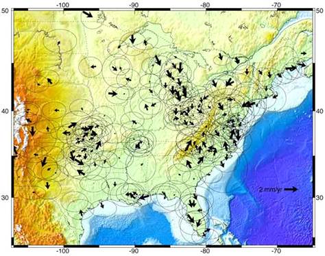
This illustration shows horizontal movements of Earth's crust in North America. Larger arrows represent greater annual movement. Source: Eric Calais/ Perdue University
So I am guessing at this point you are wondering how in the world this could be happening? The answer is simple on one level but overwhelmingly complex on another.
I will give the easy answer first:
The Earth is trying to fix itself after being stepped on for thousands of years.
And now the more complex answer:
The last of the massive ice age glaciers, which receded 10,000 years ago, caused the crust of the Earth to compress under their weight.
Around 110,000 years ago the Earth began to cool and glaciers, or giant and slow moving flows of ice that are created by compacted snow on sides of mountains, took over a huge amount of real estate in the northern hemisphere. See the map below to understand the extent of the ice sheet that originated at the north pole of the Earth.
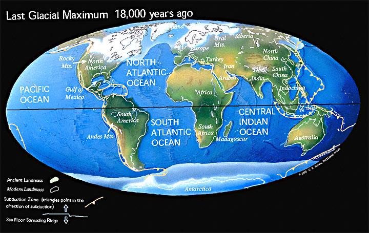
Glacial Maximum. This map represents the reach of the glaciers during the last Ice age in the Northern Hemisphere. Notice the large ice sheet over the northeast of the United States. Source: http://www.scotese.com/
As you can see the glaciers reached their maximum around 18,000 years ago. Soon after this glacial max a period of warming caused the ice sheet to melt and recede back into the northern part of the hemisphere where it remains (especially in Greenland) today.
Specifically where I live in the Hudson Valley we had the Laurentide Ice Sheet. Well over a mile of ice was stacked right over where I am sitting while I write this blog! “The Laurentide ice sheet advanced and retreated over a period of 60,000 years. The last advance reached maximum 22,000 years ago, extending from southeastern Alberta across what are now the Great Lakes to the east coast” (New York Nature). The Hudson Valley itself was created by the epic forces glaciers exerted to carve out the land beneath them. In fact there were four different advances and retreats of glaciers during this time in the Hudson Valley.
Each time the glaciers advanced the pushed out the topsoil beneath them. Ever wonder why New Jersey is called the Garden State? It is because the glaciers took all of New York’s good topsoil for growing!
The glaciers picked up and pushed the soil to the south and in return deposited the large boulders and stones (glacial till) that we have in the Hudson Valley. Trying to dig a hole is an hour long process where I live in Ulster County because of the amount of rocks deposited by the ice sheet.
The glaciers did more than drop rocks and crush the Earth. During the last ice age the present form of the Hudson River was carved out. “Near Storm King, there is a place on the Hudson River bed that is nearly 200 feet below sea level. When the glaciers melted and the sea level rose back to normal, these streams and rivers flooded with sea water. The Hudson is in certain places like Norwegian fjords, drowned valleys” (Watertrail).
I would love to give a number for how much glaciers weigh but after researching I cannot seem to find anything. What I can tell you is that the pounds per square inch beneath the glacier were most likely in the thousands.
Some may think that the Earth is too large to be dented but that is not the case at all. The Laurentide Ice Sheet was so heavy that it crushed the crust and caused it to sag into the mantle! When the ice melted the crust had to regain its former shape.
Think of crushing a plastic bottle with your hands. Your hands are the glaciers and the bottle is the Earth’s crust. When you remove your hands some areas of the bottle spring back right away simply because there is no longer any pressure. The other parts of the bottle do not spring back so quickly. To fix this you have to blow into the bottle to make it pop back into place. You blowing into the bottle represents the heat and pressure that is pushed onto the bottom of the crust by the liquid mantle inside the Earth. When the glaciers pushed down the crust beneath them the liquid mantle was pushed out of the way by the weight of the crust above.
If you need to see a visual animation of this process to better understand it please go here.
Let us go back to the beginning of this blog and return to the original topic- the northeast of the United States moving south. If you have not been able to figure out why it is moving south, that is okay, because it took me a while to figure it out, too! The reality is the continent is rebounding, even today, since the glaciers left.
Scientists knew about “post-glacial rebound” for years before the measurements presented the fact that the northeast is shifting south. They were baffled to see this result and immediately tried to explain it. The answer? It has everything to do with the rebounding process.
The continent is stretching horizontally as it bounces back from the compression process. “It turns out this slow recovery is also causing a very small horizontal shift, said Eric Calais, a geophysicist at Purdue University in Indiana. The movement varies from one spot to another, but the overall effect amounts to a 1-millimeter shortening per year of the distance between Florida and the Hudson Bay in northeastern Canada. That's about an inch every 25 years” (MSNBC).
If you had a balloon and pushed it against the wall it would have to stretch out sideways. That process is the same one that is happening to the crust. It is stretching sideways as it is pushed from beneath.
This rebound is not exactly a subtle process. Many of the smaller earthquakes that occur in the northeast United States are caused by the crust trying to fix itself. Here is a map of earthquakes in New York from 1990-2006 from the USGS.
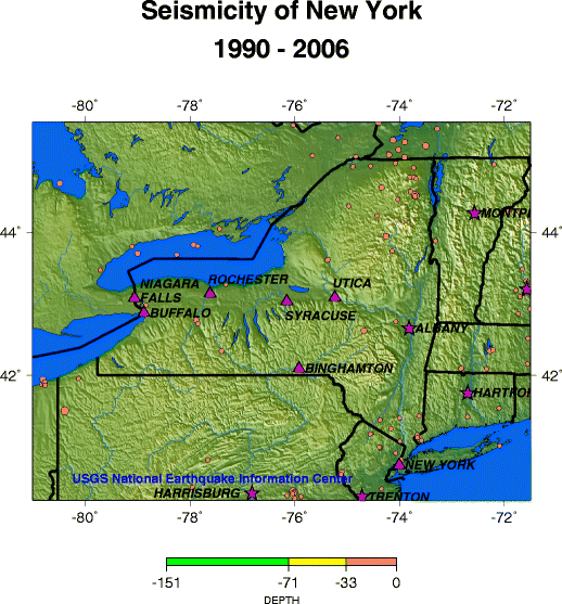
Seismicity of New York (1990-2006). Notice the smaller earthquakes in the center of the state. Source: USGS
The earthquakes around New York City and northern New York were most likely caused by faults, not by glacial rebound. However the smaller earthquakes across the state were probably caused by the crust suddenly moving as it relaxes.
In May of last year Maine suffered dozens of microquakes within a matter of days. “All the quakes measured below magnitude 2, and many were too small to feel. Early notification came from residents’ calls to local authorities, reporting the sound of gunshots and unexpected blasting. It was actually the sound of Earth’s crust moving” (Wired).
When the glacier was sitting on the northeast U.S. the crust was pushed down 500 feet!
Let me put this in perspective: My elevation is 155 feet above sea level. If the glacier was sitting on top of the crust where I am right now I would be below sea level. If we somehow removed the glacier quickly and allowed the water from the ocean to flow in I would be under the Atlantic Ocean right now!
Conclusion:
The last glaciers in the northeast melted thousands of years ago. This is a blink of the eye in geological time. The rebound process will continue for hundreds if not thousands of years to come. The earthquakes will not be huge (over 4.0M) but I can guarantee that there will be hundreds of headlines over the next millennia as the Earth tries to heal the damage that the glaciers caused to the crust.
Of course if another ice age comes along the crust will have to deal with this ALL over again.
Don’t worry, though, Earth is used to it. :-)
Thanks for reading!
- The Weather Dork
Sources:
http://watertrail.org/geology/
http://www.scotese.com
http://www.wired.com/wiredscience/2011/05/maine-earthquakes/
http://www.msnbc.msn.com/id/10498900/ns/technology_and_science-science/t/northeast-moving-south/
http://www.newyorknature.net/IceAge.html
http://www.fccj.info/gly1001/animations/Chapter6/GlacialIsostasy.html
http://www.geo.hunter.cuny.edu/bight/coast.html
http://www.usgs.gov
 RSS Feed
