In most cases weather on the Earth evens itself out in the end...or at least it tries. That is one of the reasons we get hurricanes in the Summer- the Earth is trying to "cool off" the equatorial latitudes and send warm air and moisture away toward the poles.
Many people are talking about this warm up we're having. Someone might see a 60 degree reading in the Hudson Valley before the end of the week. This means no more snow pack. In fact, I think it'll be gone by the weekend in most of the Hudson Valley.
What it does not mean is that we won't see cold temperatures ever again.
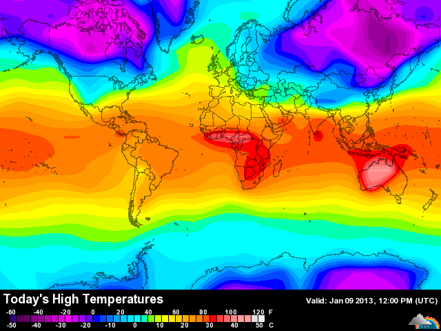
This map depicts the high temperatures today on the Earth. Australia is dealing with dangerous and deadly temperatures pushing 120 degrees! This heat is unheard of in much of the continent. Wildfires are raging and firefighters and citizens are losing their lives or getting hurt.
When you see extreme heat somewhere on the Earth you need to look for the opposite that balances out the climate in the atmosphere of the globe. That opposite is in Siberia and northern Canada where HIGH temperatures are only reaching a dangerous -50 or so.
The point of this short blog is that there are patterns at work on a global scale that are hardly ever mentioned but are always in place. Think of the weather of the Earth as being gears in a clock- they all turn to keep the system going and each gear can change the entire system if it fails. We will see cold air again in the United States- in fact, the cold air in Siberia may shift and spin into Canada with part of it kissing the northeast United States come the end of January. This would mean low temperatures WELL below zero and highs, once again, in the single digits or so.
This pattern would also lend itself to wintery precipitation, especially in the Mid-Atlantic if the cold air really pushes south. That is something to watch as we head into the second half of January.
So if you like Winter and snow keep the faith. If you don't like Winter and snow then enjoy the next few days.
Finally, trust that the Earth's atmosphere will do its best to balance temperatures and precipitation as well it can. The weather may be deadly and dangerous but it is how our atmosphere maintains equilibrium. If it can't maintain it, someone will get a giant storm to help balance things out.


 RSS Feed
